IMAGES TAKEN NEAR TO
Scarth Close, MANCHESTER, M22 9SD
Introduction
This page details the photographs taken nearby to Scarth Close, M22 9SD by members of the Geograph project.
The Geograph project started in 2005 with the aim of publishing, organising and preserving representative images for every square kilometre of Great Britain, Ireland and the Isle of Man.

There are currently over 7.5m images from over14,400 individuals and you can help contribute to the project by visiting https://www.geograph.org.uk
Image Map
Images are licensed for reuse under creativecommons.org/licenses/by-sa/2.0
Notes
- Clicking on the map will re-center to the selected point.
- The higher the marker number, the further away the image location is from the centre of the postcode.
Image Listing (5 Images Found)
Images are licensed for reuse under creativecommons.org/licenses/by-sa/2.0
Image
Details
Distance
1
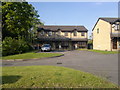
Greenwood Road, Benchill
Townhouses occupy the overwhelming majority of Benchill and Newall Green, and these examples just off Greenwood Road in south Manchester are no exception.
Image: © Steven Haslington
Taken: 21 May 2012
0.11 miles
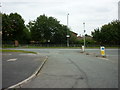
2
Simonsway
Looking across Simonsway towards the MEA.
Image: © DS Pugh
Taken: 14 Dec 2018
0.19 miles
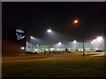
4
Simonsway nears Poundswick Lane junction
Image: © Colin Pyle
Taken: 20 Jun 2014
0.23 miles
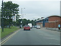
5

Arrested Development
New Police station at Wythenshawe Forum (to the left of shot). This architectural blueprint seems to be copied at other stations recently built in the Greater Manchester area (notably Swinton). The Blue Lamp on the top echoes a bygone era.
Image: © Roger May
Taken: 4 Oct 2005
0.24 miles