1
Robinswood Road Tramstop, Inbound
Metrolink Bombardier tram number 3086 waits at the Robinswood Road stop on its journey towards Manchester (Cornhill).
The Robinswood Road stop is unusual for the Airport line in that it is the only one where the alignment uses neither an island platform nor are the two platforms facing each other.
The track here runs along a strip of land on the southern side of Simonsway. The inbound (towards Manchester) platform at the Robinswood Road stop is situated to the east of the signalled junction with Brownley and Ruddpark Roads whilst the outbound (towards Manchester Airport) platform is to the west of this junction which replaced the roundabout which used to be here.
Image: © David Dixon
Taken: 3 Nov 2014
0.13 miles
2
St Andrew's Methodist Church, Wythenshawe
St Andrew's Church is at the junction of Simonsway and Brownley Road.
Image: © David Dixon
Taken: 2 Nov 2012
0.14 miles
3
Robinswood Road Tram Station
Alongside Simonsway.
Image: © Trevor Harris
Taken: 3 Sep 2021
0.14 miles
4
Wythenshawe, St Andrew's Methodist Church
St Andrew's Church is at the junction of Simonsway and Brownley Road.
Image: © David Dixon
Taken: 2 Nov 2012
0.14 miles
5
Metrolink Airport Line, Simonsway
Between Robinswood Road and Peel Hall, the tramway route uses a reserved way alongside the southern side of Simonsway. Here, Bombardier tram number 3063 is travelling towards Manchester Airport.
Image: © David Dixon
Taken: 3 Nov 2014
0.14 miles
6
St Andrew's Methodist Church, Wythenshawe
Looking across Simonsway towards St Andrew's Church.
Image: © David Dixon
Taken: 3 Nov 2014
0.14 miles
7
St. Andrew's church
Methodist church in Wythenshawe.
Image: © philandju
Taken: 19 Sep 2017
0.14 miles
8
Wythenshawe, St Andrew's Church
St Andrew's Church is at the junction of Simonsway and Brownley Road.
Image: © David Dixon
Taken: 2 Nov 2012
0.15 miles
9
Wythenshawe, St Andrew's Church
Image: © David Dixon
Taken: 3 Nov 2014
0.15 miles
10
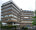
Delta House, Wavell Road, Manchester
An interesting Y-shaped 1960s office block, the upper storeys above a hexagonal ground floor.
I would have tried to get a closer look, but the "ISO27001-compliant building has some of the most sophisticated security of any data centre in Europe ... with an on-site police-linked, NSI Gold Approved, BS5979 certified control room and alarm receiving centre [it is] unique in the UK. ...biometric access controls, virtual tripwires, visitor turnstiles and man-traps, and full-height perimeter fencing provide multiple layers of physical security." Operated by Teledata UK Ltd.
Image: © Stephen Richards
Taken: 26 May 2016
0.15 miles


