IMAGES TAKEN NEAR TO
Crawley Avenue, MANCHESTER, M22 5FA
Introduction
This page details the photographs taken nearby to Crawley Avenue, M22 5FA by members of the Geograph project.
The Geograph project started in 2005 with the aim of publishing, organising and preserving representative images for every square kilometre of Great Britain, Ireland and the Isle of Man.

There are currently over 7.5m images from over14,400 individuals and you can help contribute to the project by visiting https://www.geograph.org.uk
Image Map
Images are licensed for reuse under creativecommons.org/licenses/by-sa/2.0
Notes
- Clicking on the map will re-center to the selected point.
- The higher the marker number, the further away the image location is from the centre of the postcode.
Image Listing (40 Images Found)
Images are licensed for reuse under creativecommons.org/licenses/by-sa/2.0
Image
Details
Distance
1
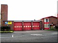
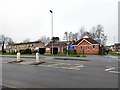
Wythenshawe Fire Station
Fire station on Brownley Road, Wythenshawe.
Image: © Roger May
Taken: 17 Feb 2006
0.02 miles
4
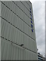
Edwards, Wythenshawe
Taken on Saturday 28th April 2012 - Formerly Edwards Court, these flats were renovated in 2008
Image: © Mikey
Taken: 28 Apr 2012
0.05 miles
5
Edwards Court
Housing in Wythenshawe.
Image: © Peter McDermott
Taken: 23 Jul 2012
0.06 miles
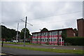
7

Edwards Court, Birch Tree Drive, Manchester
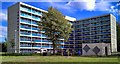
Two eight-storey blocks, Edwards Court on the left and Birch Tree Court on the right, each containing 86 flats. Built c1965. Originally there were four blocks but two have been demolished.
Image: © Stephen Richards
Taken: 26 May 2016
0.07 miles
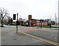
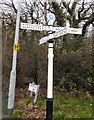
8
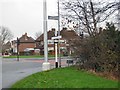
Signpost at Crossacre
This old looking signpost on the corner of Brownley Road and Cross Acres Road may not be as old as it looks. The circle which should show the local authority and an OS grid reference has been replaced by an advertisement.
Image: © Gerald England
Taken: 24 Jan 2019
0.07 miles
9
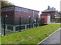
Power plant room and electricity sub station
Image: © Alex McGregor
Taken: 2 Jun 2011
0.07 miles
10
Signpost at Crossacre
This old looking signpost on the corner of Brownley Road and Cross Acres Road may not be as old as it looks. The circle which should show the local authority and an OS grid reference has been replaced by an advertisement.
Image: © Gerald England
Taken: 24 Jan 2019
0.09 miles