IMAGES TAKEN NEAR TO
Bradnor Road, MANCHESTER, M22 4TE
Introduction
This page details the photographs taken nearby to Bradnor Road, M22 4TE by members of the Geograph project.
The Geograph project started in 2005 with the aim of publishing, organising and preserving representative images for every square kilometre of Great Britain, Ireland and the Isle of Man.

There are currently over 7.5m images from over14,400 individuals and you can help contribute to the project by visiting https://www.geograph.org.uk
Image Map
Images are licensed for reuse under creativecommons.org/licenses/by-sa/2.0
Notes
- Clicking on the map will re-center to the selected point.
- The higher the marker number, the further away the image location is from the centre of the postcode.
Image Listing (15 Images Found)
Images are licensed for reuse under creativecommons.org/licenses/by-sa/2.0
Image
Details
Distance
1
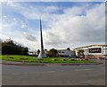
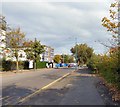
Bradnor Road
In the middle of a roundabout that leads into Sharston Industrial Estate is a piece of public art. I haven't been able to discover any information about it. In 2008 Steve Fareham described it as a Spire Image but I'm not sure about that. On the right is Broderick's http://brodericks.co.uk/ who manufacture coffee vending machines and other products. Their address is given as Alpha Point, Bradnor Road so maybe that is the name of the artwork.
Image: © Gerald England
Taken: 14 Oct 2017
0.04 miles
2
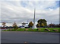
Alpha Point
I think that may be the title of this artwork on Bradnor Road Image off Sharston Road but I am not certain. In 2008 Steve Fareham described it as a Spire Image
Image: © Gerald England
Taken: 14 Oct 2017
0.04 miles
3
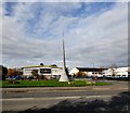
Sharston Industrial Estate
Broderick's http://brodericks.co.uk/ who manufacture coffee vending machines and other products give their address as Alpha Point, Bradnor Road Image In front is a piece of artwork Image about which I've been unable to discover any information. In 2008 Steve Fareham described it as a Spire Image
Image: © Gerald England
Taken: 14 Oct 2017
0.04 miles
4
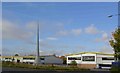
Spire on Bradnor Road
With Brodericks Coffee warehouse in the background.
Image: © Steve Fareham
Taken: 17 Oct 2008
0.05 miles
5
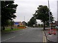
Sharston Road
The B5168 approaching Longley Lane.
Image: © Gerald England
Taken: 14 Oct 2017
0.14 miles
6
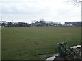
Wythenshawe Cricket Club - Ground
Wythenshawe CC's Longley Lane ground.
Image: © BatAndBall
Taken: 25 Mar 2013
0.18 miles
7
Longley Lane, Northenden
Looking in a southeasterly direction along Longley Lane, Northenden near its junction with Sharston Road. Sharston Industrial Area to the right, a residential area to the left. SJ83248948.
Image: © Keith Williamson
Taken: 8 Sep 2005
0.18 miles
8
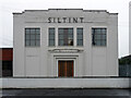
124 Longley Lane, Manchester
The Sharston Industrial Area has several modest 1930s Deco factories.
Siltint provides "Thin Film Vacuum Coating processes for the precision optical and opto-electronic industries."
Image: © Stephen Richards
Taken: 26 May 2016
0.20 miles
9
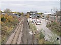
Northenden railway station (site), Greater Manchester
Opened in 1866 on the Cheshire Line Committee's line from Stockport to Altrincham, this station closed to passengers in 1964 and completely in 1965. View east towards Cheadle North and Stockport Tiviotdale. The main building was to the left of the line, in front of the signalbox.
Image: © Nigel Thompson
Taken: 13 Nov 2012
0.20 miles
10
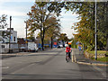
Longley Lane (B5166)
Longley lane, between Gatley and Northenden
Image: © David Dixon
Taken: 27 Sep 2011
0.22 miles