IMAGES TAKEN NEAR TO
West View Road, MANCHESTER, M22 4LP
Introduction
This page details the photographs taken nearby to West View Road, M22 4LP by members of the Geograph project.
The Geograph project started in 2005 with the aim of publishing, organising and preserving representative images for every square kilometre of Great Britain, Ireland and the Isle of Man.

There are currently over 7.5m images from over14,400 individuals and you can help contribute to the project by visiting https://www.geograph.org.uk
Image Map
Images are licensed for reuse under creativecommons.org/licenses/by-sa/2.0
Notes
- Clicking on the map will re-center to the selected point.
- The higher the marker number, the further away the image location is from the centre of the postcode.
Image Listing (20 Images Found)
Images are licensed for reuse under creativecommons.org/licenses/by-sa/2.0
Image
Details
Distance
1
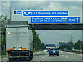
M60 Northenden
Approaching junction 5 of the M60 clockwise and the turn off for central Manchester.
Image: © Andy Farrington
Taken: 20 Jun 2011
0.10 miles
5
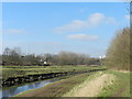
River Mersey, East Didsbury
The M60 motorway is just the other side of the river; here there is part of the Trans Pennine Trail.
Image: © Peter Barr
Taken: 27 Feb 2013
0.16 miles
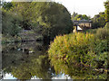
6
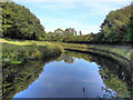
River Mersey
The River Mersey, looking upstream from Ford Lane.
Image: © David Dixon
Taken: 27 Sep 2011
0.17 miles
8
River Mersey
The River Mersey, looking upstream from Ford Lane.
Image: © David Dixon
Taken: 27 Sep 2011
0.18 miles
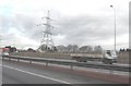
9
River Mersey
Looking downstream from Ford Lane, towards the bridge carrying the M60 motorway over the river.
Image: © David Dixon
Taken: 27 Sep 2011
0.18 miles
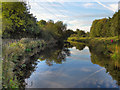
10
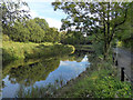
River Mersey
The River Mersey, alongside Ford Lane.
Image: © David Dixon
Taken: 27 Sep 2011
0.18 miles