IMAGES TAKEN NEAR TO
Brownley Road, MANCHESTER, M22 4GA
Introduction
This page details the photographs taken nearby to Brownley Road, M22 4GA by members of the Geograph project.
The Geograph project started in 2005 with the aim of publishing, organising and preserving representative images for every square kilometre of Great Britain, Ireland and the Isle of Man.

There are currently over 7.5m images from over14,400 individuals and you can help contribute to the project by visiting https://www.geograph.org.uk
Image Map
Images are licensed for reuse under creativecommons.org/licenses/by-sa/2.0
Notes
- Clicking on the map will re-center to the selected point.
- The higher the marker number, the further away the image location is from the centre of the postcode.
Image Listing (16 Images Found)
Images are licensed for reuse under creativecommons.org/licenses/by-sa/2.0
Image
Details
Distance
5
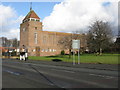
Benchill - Church of St. Luke The Physician
Image: © Peter Whatley
Taken: 23 Jan 2009
0.19 miles
7
Shops in Hollyhedge Road, Wythenshawe, Manchester
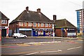
One of several blocks of shops in this part of Hollyhedge Road. From left to right:- Ladbrokes, a betting shop at No. 181, Costcutter local supermarket at No. 183, Bobo Goa, Fish & chips & Chinese cuisine (takeaway food shop) at No. 185 and Kurry Hut (kebab and fast food takeaway shop) at No. 187. The road is on the line of the Manchester Metrolink to Manchester Airport and the tram tracks can be seen running in the road.
Image: © P L Chadwick
Taken: 30 Dec 2014
0.23 miles
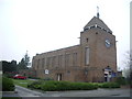
8
St. Luke the Physician
St. Luke's Church, Benchill Wythenshawe. I waited AGES for a break in traffic, but at that time of the afternoon I just didn't have any luck :)
Image: © Roger May
Taken: 4 Oct 2005
0.23 miles
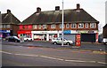
9
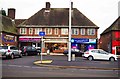
Shops and bus stop in Hollyhedge Road, Wythenshawe, Manchester
One of several blocks of shops in this part of Hollyhedge Road. From left to right:- Threadgold Cycles, a bicycle shop & repairer, established in 1906, at No. 189, McColl's, a local convenience store and newsagent at Nos. 191-193, and Kebabalicious, a takeaway shop, at No. 195. Opposite McColl's is a bus stop. The road is also on the line of the Manchester Metrolink to Manchester Airport and the tram tracks can be seen running in the road.
Image: © P L Chadwick
Taken: 30 Dec 2014
0.23 miles
10
Shops in Hollyhedge Road, Wythenshawe, Manchester
One of several blocks of shops in this part of Hollyhedge Road. From left to right:- Shell-Lose, tanning & beauty saloon at No. 175, Allison's Bakery at No. 177 and Fostering Solutions - Wythenshawe, an independent fostering provider, at No. 179. Since this photograph was taken, Shell-Lose appears to have left No. 175, which is currently occupied by a tattoo & piercing studio. The road is on the line of the Manchester Metrolink to Manchester Airport and one of the tram tracks can be seen running in the road.
Image: © P L Chadwick
Taken: 30 Dec 2014
0.24 miles