IMAGES TAKEN NEAR TO
Woodhouse Road, MANCHESTER, M22 1PZ
Introduction
This page details the photographs taken nearby to Woodhouse Road, M22 1PZ by members of the Geograph project.
The Geograph project started in 2005 with the aim of publishing, organising and preserving representative images for every square kilometre of Great Britain, Ireland and the Isle of Man.

There are currently over 7.5m images from over14,400 individuals and you can help contribute to the project by visiting https://www.geograph.org.uk
Image Map
Images are licensed for reuse under creativecommons.org/licenses/by-sa/2.0
Notes
- Clicking on the map will re-center to the selected point.
- The higher the marker number, the further away the image location is from the centre of the postcode.
Image Listing (10 Images Found)
Images are licensed for reuse under creativecommons.org/licenses/by-sa/2.0
Image
Details
Distance
1
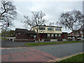
The Red Beret
Pub on Cornishway in Woodhouse Park
Image: © Richard Croft
Taken: 23 Apr 2013
0.05 miles
2
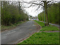
Woodhouse Lane
Disused road near Manchester Airport
Image: © Richard Croft
Taken: 23 Apr 2013
0.14 miles
3
Tram heading for Manchester
A tram leaving the airport heads towards Manchester.
Image: © DS Pugh
Taken: 22 Mar 2017
0.18 miles
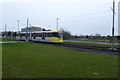
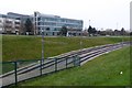
4
Metrolink
Finishing touches to the Metrolink line to Manchester Airport.
Image: © Peter McDermott
Taken: 16 Aug 2014
0.18 miles
5
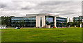
Manchester Airport
Office buildings near Manchester Airport.
Image: © Peter McDermott
Taken: 16 Aug 2014
0.18 miles
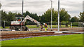
6
Diving under the road
The tram line to Manchester Airport dives underneath Ringway Road West to reach the airport station.
Image: © DS Pugh
Taken: 22 Mar 2017
0.19 miles
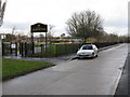
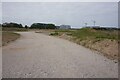
8
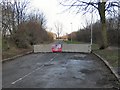
Road Block
On the 1940's OS map, this road used to connect Woodhouse Park (behind shot) with Heyhead. The post-war development of this entire area, with Manchester International airport less than half a mile beyond this barrier, has transformed the landscape beyond all recognition.
Image: © Roger May
Taken: 17 Feb 2006
0.20 miles
9
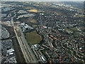
Manchester Airport from the air
The northern fringes of the airport, including the railway line. Woodhouse Park is on the right.
Image: © Thomas Nugent
Taken: 2 Apr 2013
0.20 miles