IMAGES TAKEN NEAR TO
Prinknash Road, MANCHESTER, M22 0FE
Introduction
This page details the photographs taken nearby to Prinknash Road, M22 0FE by members of the Geograph project.
The Geograph project started in 2005 with the aim of publishing, organising and preserving representative images for every square kilometre of Great Britain, Ireland and the Isle of Man.

There are currently over 7.5m images from over14,400 individuals and you can help contribute to the project by visiting https://www.geograph.org.uk
Image Map
Images are licensed for reuse under creativecommons.org/licenses/by-sa/2.0
Notes
- Clicking on the map will re-center to the selected point.
- The higher the marker number, the further away the image location is from the centre of the postcode.
Image Listing (31 Images Found)
Images are licensed for reuse under creativecommons.org/licenses/by-sa/2.0
Image
Details
Distance
1
Black Path pedestrian link, Wythenshawe, Manchester
Image: © Anthony O'Neil
Taken: 29 Mar 2011
0.08 miles
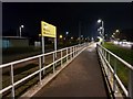
2
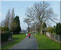
Portway near St Anthony's, Wythenshawe
Image: © Anthony O'Neil
Taken: 29 Mar 2011
0.10 miles
3
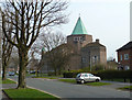
St Anthony's Church, Portway, Wythenshawe
Image: © Anthony O'Neil
Taken: 29 Mar 2011
0.11 miles
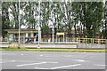
4
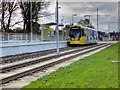
Robinswood Road Tramstop, Inbound
Metrolink Bombardier tram number 3086 waits at the Robinswood Road stop on its journey towards Manchester (Cornhill).
The Robinswood Road stop is unusual for the Airport line in that it is the only one where the alignment uses neither an island platform nor are the two platforms facing each other.
The track here runs along a strip of land on the southern side of Simonsway. The inbound (towards Manchester) platform at the Robinswood Road stop is situated to the east of the signalled junction with Brownley and Ruddpark Roads whilst the outbound (towards Manchester Airport) platform is to the west of this junction which replaced the roundabout which used to be here.
Image: © David Dixon
Taken: 3 Nov 2014
0.11 miles
5
Robinswood Road Tram Station
Alongside Simonsway.
Image: © Trevor Harris
Taken: 3 Sep 2021
0.11 miles
6
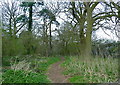
Hatchett's Wood, Wythenshawe, Manchester
Image: © Anthony O'Neil
Taken: 29 Mar 2011
0.13 miles
7
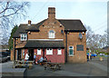
The Portway pub, Wythenshawe, Manchester
Image: © Anthony O'Neil
Taken: 29 Mar 2011
0.13 miles
8
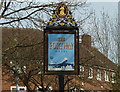
Pub sign - Wythenshawe
A reminder of its proximity to Manchester Airport.
Image: © Anthony O'Neil
Taken: 29 Mar 2011
0.14 miles
9
Tram stop on Simonsway
Robinswood Road stop for trams in an eastbound direction.
Image: © DS Pugh
Taken: 14 Dec 2018
0.14 miles
10
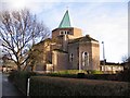
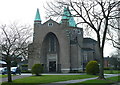
Parish Church of St. Anthony
Stylish brick-built church at Woodhouse Park.
Image: © Roger May
Taken: 17 Feb 2006
0.15 miles