IMAGES TAKEN NEAR TO
Edge Lane, MANCHESTER, M21 9HE
Introduction
This page details the photographs taken nearby to Edge Lane, M21 9HE by members of the Geograph project.
The Geograph project started in 2005 with the aim of publishing, organising and preserving representative images for every square kilometre of Great Britain, Ireland and the Isle of Man.

There are currently over 7.5m images from over14,400 individuals and you can help contribute to the project by visiting https://www.geograph.org.uk
Image Map
Images are licensed for reuse under creativecommons.org/licenses/by-sa/2.0
Notes
- Clicking on the map will re-center to the selected point.
- The higher the marker number, the further away the image location is from the centre of the postcode.
Image Listing (26 Images Found)
Images are licensed for reuse under creativecommons.org/licenses/by-sa/2.0
Image
Details
Distance
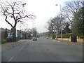
1
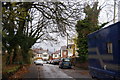
Barway Road, Chorlton
A quiet residential road off Edge Lane.
Image: © Bill Boaden
Taken: 7 Dec 2013
0.05 miles
2
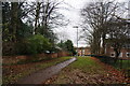
Footpath off Edge Lane, Chorlton
It leads to sheltered housing, and you can eventually get through to the River Mersey.
Image: © Bill Boaden
Taken: 7 Dec 2013
0.06 miles
3
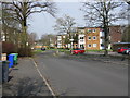
Chorlton - Meadow Court Flats On Hackness Road
Image: © Peter Whatley
Taken: 1 Apr 2009
0.07 miles
4
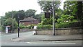
Corner of Wilbraham Road and Hampton Road
On the corner is the Woodstock B&B.
Image: © Gerald England
Taken: 13 Jun 2012
0.07 miles
6
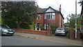
253 Ryebank Road, Chorlton-cum-Hardy
253 Ryebank Road is a lovely suburban detached home opposite Longford Park in Greater Manchester, England. The park is located in Stretford in the Trafford borough of Greater Manchester, but Ryeland Road is the district boundary with the City of Manchester, meaning the house is located in the Chorlton-cum-Hardy area of Manchester.
Image: © Steven Haslington
Taken: 20 Jul 2014
0.15 miles
7
Camouflaged buildings at Turn Moss Playing Fields, Stretford
I assume these buildings formed part of an army camp dating from WWII but I've not been able to find out anything about the site. The buildings are currently used as changing rooms for the surrounding playing fields.
Image: © Phil Champion
Taken: 24 Apr 2011
0.15 miles
8
Camouflaged buildings at Turn Moss Playing Fields, Stretford (former Heavy Anti-Aircraft battery)
I assumed these buildings formed part of an army camp dating from WWII but I've not been able to find out anything about the site. The large scale OS map from the mid 1950s shows a cluster of buildings looking very much like a military camp, where before the war there had been only a few isolated cottages. The building in front looks like it might have been an air raid shelter but now houses an electrical sub-station while those behind are changing rooms for the surrounding playing fields. It's been suggested to me that this might have been a filming location for 'Yanks', largely shot in the north of England and what remains might be mock ups of an army camp from dating from the 1970s. I'm not yet convinced, having examined the film closely, but the camouflage paint does looks surprisingly fresh. Does anyone have any further suggestions?
Update - January 2013: Steve Thompson, who maintains and updates the Defence of Britain Google Earth overlay, states that "this was actually a Heavy Anti Aircraft Battery. Designation G/H10. The building in the image is probably not a shelter but an ancillary building to the battery". Thanks for the info Steve.
Image: © Phil Champion
Taken: 24 Apr 2011
0.16 miles
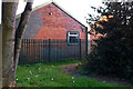
9
Buildings at Turn Moss Playing Fields, Stretford
Approximately on the site of Turn Moss Cottages (shown on pre-war maps.) I assume this was an army camp in WWII. The buildings are now used as changing rooms for the surrounding playing fields. The building in the centre of the view was an air raid shelter, now housing an electrical sub-station.
Image: © Phil Champion
Taken: 24 Apr 2011
0.16 miles
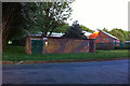
10
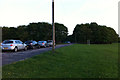
Turn Moss Playing Fields
The trees hide changing rooms and a car park, occupying the site and buildings of a wartime army camp (of which I have little information).
Image: © Phil Champion
Taken: 24 Apr 2011
0.17 miles