IMAGES TAKEN NEAR TO
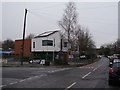
Belwood Road, MANCHESTER, M21 9FN
Introduction
This page details the photographs taken nearby to Belwood Road, M21 9FN by members of the Geograph project.
The Geograph project started in 2005 with the aim of publishing, organising and preserving representative images for every square kilometre of Great Britain, Ireland and the Isle of Man.

There are currently over 7.5m images from over14,400 individuals and you can help contribute to the project by visiting https://www.geograph.org.uk
Image Map
Images are licensed for reuse under creativecommons.org/licenses/by-sa/2.0
Notes
- Clicking on the map will re-center to the selected point.
- The higher the marker number, the further away the image location is from the centre of the postcode.
Image Listing (45 Images Found)
Images are licensed for reuse under creativecommons.org/licenses/by-sa/2.0
Image
Details
Distance
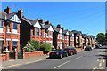
1
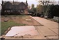
Modern houses on the site of Brook Farm, Brookburn Road
Planning approval for these three storey houses was granted in 2008. The site was formerly an Express Dairies depot, but had been derelict for some time.
Image: © Phil Champion
Taken: 26 Dec 2014
0.08 miles
2
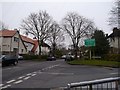
Junction of Brookburn Road with Claude Road
At the entrance to the private Chorltonville estate. http://en.m.wikipedia.org/wiki/Chorltonville
Image: © Phil Champion
Taken: 26 Dec 2014
0.10 miles
3
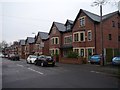
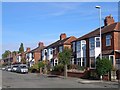
7-23 Brookburn Road, Manchester
Edwardian semis.
Image: © Stephen Richards
Taken: 27 May 2016
0.10 miles
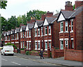
5
Brookburn Primary School
Looking down Brookburn Road to the main building at the front of the school.
Image: © Phil Champion
Taken: 26 Dec 2014
0.10 miles
6
Reeves Road
Reeves Road (eastern side), near junction with Belwood Road
Image: © Janusz Lukasiak
Taken: 12 Oct 2009
0.12 miles
7
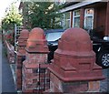
Gatepost caps
Large terracotta mouldings on top of the gate posts.
Image: © Bob Harvey
Taken: 17 Sep 2019
0.12 miles
8
Lych Gate, Chorlton Green, Chorlton Cum Hardy
Image: © D Williams
Taken: 11 Apr 2003
0.12 miles
9
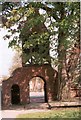
St. Clement's Churchyard, Chorlton Cum Hardy
There isn't anything left of St. Clements other than an arch leading into the old churchyard and the flat gravestones. AT the end of the churchyard you can see the Bowling Green pub
Image: © D Williams
Taken: 11 Apr 2003
0.12 miles
10
Datestone
Above the door of Image (the former police station) is the date 1885. As I asked my way around town that date came up over and over again. There must have been a lot of building round here in 1885
Image: © Bob Harvey
Taken: 17 Sep 2019
0.13 miles