IMAGES TAKEN NEAR TO
Wilbraham Road, MANCHESTER, M21 9AF
Introduction
This page details the photographs taken nearby to Wilbraham Road, M21 9AF by members of the Geograph project.
The Geograph project started in 2005 with the aim of publishing, organising and preserving representative images for every square kilometre of Great Britain, Ireland and the Isle of Man.

There are currently over 7.5m images from over14,400 individuals and you can help contribute to the project by visiting https://www.geograph.org.uk
Image Map (Loading...)


Getting Data...Please wait
Leaflet Map data © OpenStreetMap
Images are licensed for reuse under creativecommons.org/licenses/by-sa/2.0
Notes
- Clicking on the map will re-center to the selected point.
- The higher the marker number, the further away the image location is from the centre of the postcode.
Image Listing (70 Images Found)
Images are licensed for reuse under creativecommons.org/licenses/by-sa/2.0
Image
Details
Distance
1
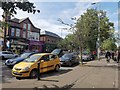
HSBC Bank, Chorlton
The HSBC bank on the corner of Barlow Moor Road and Wilbraham Road.
Image: © Gerald England
Taken: 28 Apr 2014
0.01 miles
2
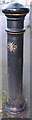
Bee on a Bollard
Bollard with Manchester's bee design, supposed to represent the busyness of the working men, and the power of their collective effort.
Image: © Bob Harvey
Taken: 17 Sep 2019
0.01 miles
3
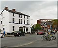
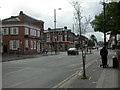
Chorlton Cross
The junction of Barlow Moor Road and Wilbraham Road, Chorlton. Otherwise known as the Four Banks due to the presence of branches of RBS, Nat West, HSBC and Santander on the four corners.
Image: © Phil Champion
Taken: 19 Apr 2014
0.01 miles
4
Chorlton Cross
Looking across Wilbraham Road (A6010) at the crossroads with Manchester Road/Barlow Moor Road (B5217).
Image: © David Dixon
Taken: 12 Jun 2011
0.01 miles
5
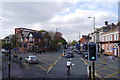
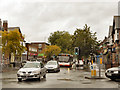
Chorlton Crossroads
The junction of Wilbraham and Barlow Moor Roads; also known as Four Banks, as there is a bank on each corner.
Image: © Mike Faherty
Taken: 29 Aug 2009
0.01 miles
6
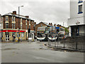
Disabled parking bays on Wilbraham Road, Chorlton
Image: © Phil Champion
Taken: 14 Sep 2019
0.02 miles
7
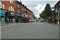
Chorlton Cross
Looking along Wilbraham Road (A6010) at its crossroads with Barlow Moor Road/Manchester Road (B5217).
Image: © David Dixon
Taken: 12 Jun 2011
0.02 miles
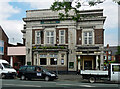
9
The Royal Oak
The Royal Oak public house on Manchester Road, Chorlton-Cum-Hardy
Image: © David Dixon
Taken: 12 Jun 2011
0.04 miles
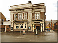
10
Royal Oak, Barlow Moor Road, Manchester
Fancy brick and terracotta pub, now a Greene King but previously a Threlfalls pub as evidenced by the parapet lettering.
Image: © Stephen Richards
Taken: 27 May 2016
0.04 miles