IMAGES TAKEN NEAR TO
Zetland Road, MANCHESTER, M21 8TJ
Introduction
This page details the photographs taken nearby to Zetland Road, M21 8TJ by members of the Geograph project.
The Geograph project started in 2005 with the aim of publishing, organising and preserving representative images for every square kilometre of Great Britain, Ireland and the Isle of Man.

There are currently over 7.5m images from over14,400 individuals and you can help contribute to the project by visiting https://www.geograph.org.uk
Image Map
Images are licensed for reuse under creativecommons.org/licenses/by-sa/2.0
Notes
- Clicking on the map will re-center to the selected point.
- The higher the marker number, the further away the image location is from the centre of the postcode.
Image Listing (80 Images Found)
Images are licensed for reuse under creativecommons.org/licenses/by-sa/2.0
Image
Details
Distance
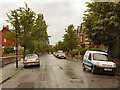
2
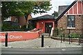
Chorlton Central Church
Chorlton Central Church, on Barlow Moor Road at Chorlton-Cum-Hardy.
Image: © David Dixon
Taken: 12 Jun 2011
0.06 miles
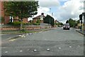
7
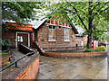
Chorlton cum Hardy
Dental surgery on the corner of Groby Road and Manchester Road.
Image: © Gerald England
Taken: 22 Apr 2010
0.09 miles
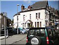
9
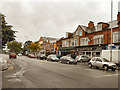
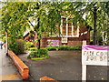
Barlow Moor Road (A5145)
Barlow Moor Road at Chorlton-Cum-Hardy, viewed from the corner of Sandy Lane.
Image: © David Dixon
Taken: 12 Jun 2011
0.11 miles
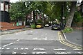
10
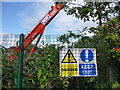
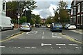
Warning notices alongside Metrolink worksite
Work was underway on the Metrolink extension to St Werburgh's Road, utilising the disused railway line.
Image: © Phil Champion
Taken: 29 Aug 2009
0.11 miles