IMAGES TAKEN NEAR TO
Meadow Bank, MANCHESTER, M21 8EF
Introduction
This page details the photographs taken nearby to Meadow Bank, M21 8EF by members of the Geograph project.
The Geograph project started in 2005 with the aim of publishing, organising and preserving representative images for every square kilometre of Great Britain, Ireland and the Isle of Man.

There are currently over 7.5m images from over14,400 individuals and you can help contribute to the project by visiting https://www.geograph.org.uk
Image Map
Images are licensed for reuse under creativecommons.org/licenses/by-sa/2.0
Notes
- Clicking on the map will re-center to the selected point.
- The higher the marker number, the further away the image location is from the centre of the postcode.
Image Listing (20 Images Found)
Images are licensed for reuse under creativecommons.org/licenses/by-sa/2.0
Image
Details
Distance
2
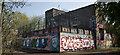
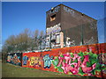
Murals to combat graffiti on the pumping station
The sluice gate building was the victim of regular graffiti which is unsightly and costly to remove. The Environment Agency and Mersey Life wanted to improve its appearance to reflect the significant improvements made to the river and the importance of the sluice gate in protecting the local area from flooding. They ran a painting project with four local schools. The pupils designed murals then painted the best designs onto the walls of the floodgates, with the help of Unity Arts, using eco friendly paints.
Image: © Ian Greig
Taken: 23 Apr 2015
0.10 miles
3

Murals to combat graffiti
The sluice gate building was the victim of regular graffiti which is unsightly and costly to remove. The Environment Agency and Mersey Life wanted to improve its appearance to reflect the significant improvements made to the river and the importance of the sluice gate in protecting the local area from flooding. They ran a painting project with four local schools. The pupils designed murals then painted the best designs onto the walls of the floodgates, with the help of Unity Arts, using eco friendly paints.
Image: © Ian Greig
Taken: 23 Apr 2015
0.11 miles
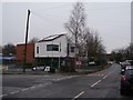
4
Pumping station
A graffiti covered building on the edge of Chorlton Meadows.
Image: © Paddy Griffin
Taken: 7 Mar 2010
0.11 miles
5
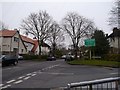
Junction of Brookburn Road with Claude Road
At the entrance to the private Chorltonville estate. http://en.m.wikipedia.org/wiki/Chorltonville
Image: © Phil Champion
Taken: 26 Dec 2014
0.11 miles
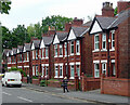
6
Brookburn Primary School
Looking down Brookburn Road to the main building at the front of the school.
Image: © Phil Champion
Taken: 26 Dec 2014
0.12 miles
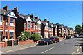
7
Modern houses on the site of Brook Farm, Brookburn Road
Planning approval for these three storey houses was granted in 2008. The site was formerly an Express Dairies depot, but had been derelict for some time.
Image: © Phil Champion
Taken: 26 Dec 2014
0.13 miles
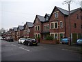
9
7-23 Brookburn Road, Manchester
Edwardian semis.
Image: © Stephen Richards
Taken: 27 May 2016
0.15 miles
10
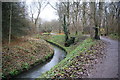
Path by Chorlton Brook
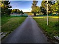
Part of Manchester's Green Corridor. All the waterways locally have been rigidly channelled, including the Mersey which is not far away.
Image: © Bill Boaden
Taken: 7 Dec 2013
0.16 miles