IMAGES TAKEN NEAR TO
Reeves Road, MANCHESTER, M21 8BT
Introduction
This page details the photographs taken nearby to Reeves Road, M21 8BT by members of the Geograph project.
The Geograph project started in 2005 with the aim of publishing, organising and preserving representative images for every square kilometre of Great Britain, Ireland and the Isle of Man.

There are currently over 7.5m images from over14,400 individuals and you can help contribute to the project by visiting https://www.geograph.org.uk
Image Map
Images are licensed for reuse under creativecommons.org/licenses/by-sa/2.0
Notes
- Clicking on the map will re-center to the selected point.
- The higher the marker number, the further away the image location is from the centre of the postcode.
Image Listing (41 Images Found)
Images are licensed for reuse under creativecommons.org/licenses/by-sa/2.0
Image
Details
Distance
1
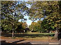
Beech Road Park
Beech Road Park. Photo taken from the corner of Beech Road & Beaumont Road.
Image: © Janusz Lukasiak
Taken: 12 Oct 2009
0.08 miles
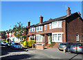
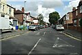
3
Reeves Road
Reeves Road (eastern side), near junction with Belwood Road
Image: © Janusz Lukasiak
Taken: 12 Oct 2009
0.09 miles
4
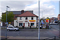
United Plumbing and DIY
Shop at the corner of Malton Avenue and Barlow Moor Road near Chorlton Bus Station.
Image: © Phil Champion
Taken: 19 Apr 2014
0.12 miles
5
Barlow Moor Road, Chorlton
The shop with the green sign is an independent off licence with an enormous selection of beers.
Image: © Des Blenkinsopp
Taken: 30 Jun 2018
0.12 miles
7
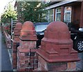
Gatepost caps
Large terracotta mouldings on top of the gate posts.
Image: © Bob Harvey
Taken: 17 Sep 2019
0.13 miles
8
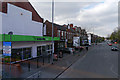
Co-operative Supermarket on Barlow Moor Road
The large building on the left, now a supermarket, was once the Palais de Luxe cinema. Prior to branding as 'The Co-operative Food' this had long been a Hanbury's supermarket, and back in the 1970s, a Tesco store. During its earlier life as a cinema there would have been an imposing entrance with green and cream tiles, fronted by a glass canopy, both long since cleared away. The white painted wall marks shape of the vanished frontage. See http://chorltonhistory.blogspot.co.uk/2012/03/forgotten-photograph-palais-de-luxe-in.html for a photo of how this would once have looked
Image: © Phil Champion
Taken: 19 Apr 2014
0.13 miles
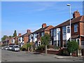
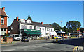
9
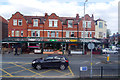
A row of restaurants on Barlow Moor Road
This Edwardian row of shops, opposite Chorlton Bus Station, was once somewhere you could buy stuff. Today it is solely occupied by restaurants (if you include the takeaway). There is another row just to the left of this view that is also dominated by bars and restaurants.
The canopy along the length of the row dates from around 2004 and replaced the dilapidated original.
Image: © Phil Champion
Taken: 19 Apr 2014
0.13 miles
10
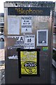
Community use
This phone box is still in use as a phone box, but the back is used in a subculture way, even down to a vulgar but quite telling poem.
Image: © Bob Harvey
Taken: 17 Sep 2019
0.13 miles