IMAGES TAKEN NEAR TO
Blanefield Close, MANCHESTER, M21 7UE
Introduction
This page details the photographs taken nearby to Blanefield Close, M21 7UE by members of the Geograph project.
The Geograph project started in 2005 with the aim of publishing, organising and preserving representative images for every square kilometre of Great Britain, Ireland and the Isle of Man.

There are currently over 7.5m images from over14,400 individuals and you can help contribute to the project by visiting https://www.geograph.org.uk
Image Map
Images are licensed for reuse under creativecommons.org/licenses/by-sa/2.0
Notes
- Clicking on the map will re-center to the selected point.
- The higher the marker number, the further away the image location is from the centre of the postcode.
Image Listing (11 Images Found)
Images are licensed for reuse under creativecommons.org/licenses/by-sa/2.0
Image
Details
Distance
1
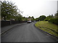
Southern part of Wintermans Road, Chorlton
Image: © Richard Vince
Taken: 12 May 2018
0.12 miles
2
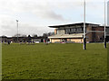
Broughton Park FC (Rugby), Hough End
The rugby ground at Hough End Playing Fields.
Image: © David Dixon
Taken: 7 Jan 2012
0.12 miles
3
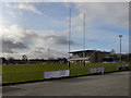
Broughton Park Rugby Football Club, Hough End.
The rugby ground at Hough End Playing Fields.
Image: © David Dixon
Taken: 7 Jan 2012
0.12 miles
4
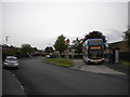
Arrowfield Road bus terminus, Chorlton
Stagecoach Manchester 10422, an Alexander Dennis Enviro 400MMC, stands in the turning circle built into the junction with Wintermans Road before working an 85 to Manchester city centre via Chorlton bus station and Whalley Range.
Image: © Richard Vince
Taken: 12 May 2018
0.14 miles
5
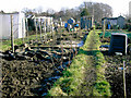
Allotments at Hough End
Popular and well-tended allotments.
Image: © Slbs
Taken: Unknown
0.19 miles
6
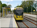
Metrolink Tram at Withington
Metrolink Bombardier M5000 tram number 3045 stands at the new West Didsbury stop, on its journey from East Didsbury to Rochdale on the first day of operation for the latest extension to the South Manchester Metrolink line.
The Metrolink line to East Didsbury, which runs along the disused railway track, opened to passenger service on Thursday 23 May, several months ahead of schedule. The 4.4km (2.7 miles) extension to the existing South Manchester line has five new stops, with services calling at Withington, Burton Road, West Didsbury, Didsbury Village and East Didsbury.
Image: © David Dixon
Taken: 23 May 2013
0.23 miles
8
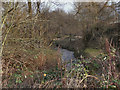
Chorlton Brook, Hough End Clough
Chorlton Brook, running through Hough End Clough
It appears that the Clough is the last remnant of an ancient wood. The 1848 OS map shows that Chorlton Brook was well wooded on both banks at that time, from its present eastern limit up to Hough End Bridge (Nell Lane). Hough End Hall, which was built in 1596, was named after the Clough; evidence of the age and importance of the wood. (taken from an information board next to the path through the Clough)
Image: © David Dixon
Taken: 7 Jan 2012
0.24 miles
9
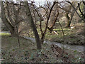
Hough End Clough
Chorlton Brook, running through Hough End Clough
It appears that the Clough is the last remnant of an ancient wood. The 1848 OS map shows that Chorlton Brook was well wooded on both banks at that time, from its present eastern limit up to Hough End Bridge (Nell Lane). Hough End Hall, which was built in 1596, was named after the Clough; evidence of the age and importance of the wood. (taken from an information board next to the path through the Clough)
Image: © David Dixon
Taken: 7 Jan 2012
0.24 miles
10
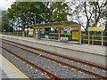
Withington Metrolink Stop
The newly opened Withington tram stop.
The Metrolink line to East Didsbury, which runs off-road, along a disused railway track, opened to passenger service on Thursday 23 May, several months ahead of schedule. The 4.4km (2.7 miles) extension to the existing South Manchester line has five new stops, with services calling at Withington, Burton Road, West Didsbury, Didsbury Village and East Didsbury.
Image: © David Dixon
Taken: 23 May 2013
0.24 miles