IMAGES TAKEN NEAR TO
Mauldeth Road West, MANCHESTER, M21 7SP
Introduction
This page details the photographs taken nearby to Mauldeth Road West, M21 7SP by members of the Geograph project.
The Geograph project started in 2005 with the aim of publishing, organising and preserving representative images for every square kilometre of Great Britain, Ireland and the Isle of Man.

There are currently over 7.5m images from over14,400 individuals and you can help contribute to the project by visiting https://www.geograph.org.uk
Image Map
Images are licensed for reuse under creativecommons.org/licenses/by-sa/2.0
Notes
- Clicking on the map will re-center to the selected point.
- The higher the marker number, the further away the image location is from the centre of the postcode.
Image Listing (71 Images Found)
Images are licensed for reuse under creativecommons.org/licenses/by-sa/2.0
Image
Details
Distance
1
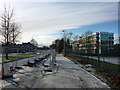
Metrolink works on Mauldeth Road West, Hough End
Preparatory work had started on the extension of the Manchester Metrolink tram network to Manchester Airport. The Airport Line will leave the existing South Manchester line just after the St Werburgh's Road stop, cutting across land next to Chorlton High School to join Mauldeth Road West, where it will run along the wide central reservation towards Barlow Moor Road.
Image: © Phil Champion
Taken: 18 Dec 2011
0.04 miles
2
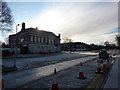
Mauldeth Road West and the Southern Hotel, Hough End
The Southern and the dual carriageway it stands alongside were built in the late 1920s. The traffic cones are a sign of preliminary works to move services to allow for the Manchester Metrolink extension towards the airport. The tram lines will run along the centre of the road.
The Southern Hotel had closed a year or so earlier and was boarded up.
Image: © Phil Champion
Taken: 18 Dec 2011
0.04 miles
3
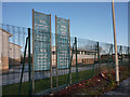
Banners at Chorlton High School
Looking through the perimeter fencing from Mauldeth Road West. The banners proclaim the academic achievements of the school, with a quote from an Ofsted inspection report.
Image: © Phil Champion
Taken: 18 Dec 2011
0.05 miles
4
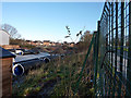
Metrolink work site near Chorlton High School
The extension of the Manchester Metrolink network to the airport is planned to open in 2016. The line will leave the South Manchester Line just after the St Werburgh's Road stop and cross land between the buildings of Chorlton High School and Mauldeth Road West, then running along the dual carriageway and Hardy Lane to a river crossing near Jackson's Boat. Preliminary work was underway in this area, mainly moving services and sorting out drainage.
Image: © Phil Champion
Taken: 18 Dec 2011
0.05 miles
5
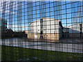
Chorlton High School buildings from Mauldeth Road West
A view through the security fencing.
Image: © Phil Champion
Taken: 18 Dec 2011
0.05 miles
6
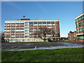
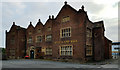
Mauldeth House, Hough End Hall and 550 Mauldeth Road West
Hough End Hall was built in the 1590s for Sir Nicholas Mosley when he was Lord of the Manor of Manchester. http://en.wikipedia.org/wiki/Hough_End_Hall
Time and the hand of the town planners has not been kind to the hall, as it sits in a sea of car parks, hemmed in by two hideous sixties office blocks to the front and side, with the buildings of Chorlton High School and associated security fences crowding in from the rear. Later in its history Hough End was sold to the Egertons of Tatton.
By the 20th century much of the interior had been lost; the fine staircase had been removed to Tatton Hall in Cheshire, and the hall was a farmhouse. Photos from the 1920s show various farm buildings in the area of the car park seen in this view. In 1969 Pevsner note that the porch had collapsed and the roof was open to the skies, describing the condition of the building as 'an unpardonable act of cruelty'. Manchester Corporation, who owned the building later carried out some renovation works, after which Hough end was used as a pub / carvery type restaurant / nightclub, closing some time in the late 1990s. In 2010 further restoration work was carried out and the hall reopened briefly as a restaurant. This closed later that year, and by December 2011 the building was to let.
http://www.manchesterconfidential.co.uk/Culture/Architecture/The-Good-the-Standard-and-the-Ugly-Hough-End-Hall
Image: © Phil Champion
Taken: 18 Dec 2011
0.05 miles
8
Mauldeth Road West
Seen here from the Metrolink tram, just as the tram line merges with the road.
Image: © David Martin
Taken: 17 Jul 2015
0.06 miles
10
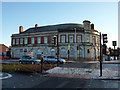
The Southern Hotel, Mauldeth Road West, Chorlton
This substantial public house was built in the 1920s at the corner of Mauldeth Road West and Nell Lane. For a number of years the pub had had an Irish theme (there being a large Irish population in the area). According to the signs the building also housed 'Mammy's Irish Kitchen' (a cafe) and the Celtic Tiger nightclub (offering live Irish music). The Southern closed in April 2011 and as of December 2011 was still boarded up and up for sale.
Image: © Phil Champion
Taken: 18 Dec 2011
0.06 miles