IMAGES TAKEN NEAR TO
Caldervale Avenue, MANCHESTER, M21 7QB
Introduction
This page details the photographs taken nearby to Caldervale Avenue, M21 7QB by members of the Geograph project.
The Geograph project started in 2005 with the aim of publishing, organising and preserving representative images for every square kilometre of Great Britain, Ireland and the Isle of Man.

There are currently over 7.5m images from over14,400 individuals and you can help contribute to the project by visiting https://www.geograph.org.uk
Image Map
Images are licensed for reuse under creativecommons.org/licenses/by-sa/2.0
Notes
- Clicking on the map will re-center to the selected point.
- The higher the marker number, the further away the image location is from the centre of the postcode.
Image Listing (69 Images Found)
Images are licensed for reuse under creativecommons.org/licenses/by-sa/2.0
Image
Details
Distance
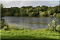
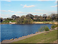
2
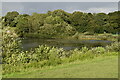
Chorlton Water Park
An ice cream van doing business at the lake shore at Chorlton Water Park which is on the site of what was once Barlow Hall Farm. Up until the 1950s the farmer flooded the field to increase the fertility of the land. As with the nearby Sale Water Park, gravel was excavated from the site and used in the construction of the M60 motorway in the 1970s. The gravel pit was subsequently flooded; creating the lake that is central to the Park today.
Chorlton Water Park is a Local Nature Reserve.
Image: © David Dixon
Taken: 1 Apr 2012
0.08 miles
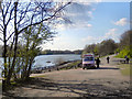
8
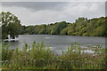
Chorlton Water Park
Chorlton Water Park is on the site of what used to be Barlow Hall Farm. Up until the 1950s the farmer flooded the field to increase the fertility of the land. As with the nearby Sale Water Park, gravel was excavated from the site and used in the construction of the M60 motorway in the 1970s. The gravel pit was subsequently flooded; creating the lake that is central to the Park today.
Chorlton Water Park is a Local Nature Reserve.
Image: © David Dixon
Taken: 1 Apr 2012
0.13 miles
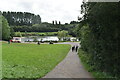
9
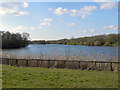
Chorlton Water Park
Chorlton Water Park is on the site of what was Barlow Hall Farm. Up until the 1950s the farmer flooded the field to increase the fertility of the land. As with the nearby Sale Water Park, gravel was excavated from the site and used in the construction of the M60 motorway in the 1970s. The gravel pit was subsequently flooded; creating the lake that is central to the Park today.
Chorlton Water Park is a Local Nature Reserve.
Image: © David Dixon
Taken: 1 Apr 2012
0.13 miles