IMAGES TAKEN NEAR TO
Caldervale Avenue, MANCHESTER, M21 7PW
Introduction
This page details the photographs taken nearby to Caldervale Avenue, M21 7PW by members of the Geograph project.
The Geograph project started in 2005 with the aim of publishing, organising and preserving representative images for every square kilometre of Great Britain, Ireland and the Isle of Man.

There are currently over 7.5m images from over14,400 individuals and you can help contribute to the project by visiting https://www.geograph.org.uk
Image Map
Images are licensed for reuse under creativecommons.org/licenses/by-sa/2.0
Notes
- Clicking on the map will re-center to the selected point.
- The higher the marker number, the further away the image location is from the centre of the postcode.
Image Listing (61 Images Found)
Images are licensed for reuse under creativecommons.org/licenses/by-sa/2.0
Image
Details
Distance
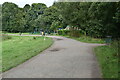
2
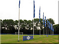
Sports Fields
This is a view of the sports field in the south western section of the square. The Umbro international Football Festival was being played out on these fields at the time.
Image: © Pam Brophy
Taken: 27 Jul 2005
0.09 miles

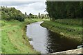
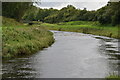
5
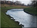
River Mersey
A small rapid in the river Mersey just upstream of Chorlton Water Park footbridge
Image: © Jim Thornton
Taken: 15 Dec 2007
0.11 miles