IMAGES TAKEN NEAR TO
Hardcastle Avenue, MANCHESTER, M21 7LL
Introduction
This page details the photographs taken nearby to Hardcastle Avenue, M21 7LL by members of the Geograph project.
The Geograph project started in 2005 with the aim of publishing, organising and preserving representative images for every square kilometre of Great Britain, Ireland and the Isle of Man.

There are currently over 7.5m images from over14,400 individuals and you can help contribute to the project by visiting https://www.geograph.org.uk
Image Map
Images are licensed for reuse under creativecommons.org/licenses/by-sa/2.0
Notes
- Clicking on the map will re-center to the selected point.
- The higher the marker number, the further away the image location is from the centre of the postcode.
Image Listing (46 Images Found)
Images are licensed for reuse under creativecommons.org/licenses/by-sa/2.0
Image
Details
Distance
1
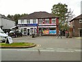
Shops on Barlow Moor Road
M&S Windows and A&K Off Licence and Groceries opposite Southern Cemetery.
Image: © Gerald England
Taken: 28 Apr 2014
0.08 miles
2
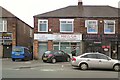
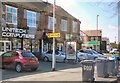
Businesses on Barlow Moor Road
Comparing with the scene on Streetview from 2008 "Press-On" an ironing service business has expanded to the left taking over a former "Claims" business into a dry cleaners. The premises to the left has changed from a "computer solutions" business into a picture-framers. To the right a former solicitors offices has become the "Premier Massala" takeaway.
Image: © Gerald England
Taken: 13 Jun 2012
0.11 miles
3
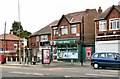
Hardy Lane Post Office
Not on Hardy Lane but round the corner on Barlow Moor Road.
Image: © Gerald England
Taken: 27 Jun 2015
0.11 miles
4
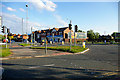
Junction of Barlow Moor Road and Mauldeth Road West, Chorlton-cum-Hardy
Image: © Phil Champion
Taken: 25 May 2007
0.12 miles
5
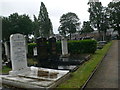
Southern Cemetery, Manchester
The area dedicated to Jewish burials. Barlow Moor Road houses in the distance.
Image: © Eirian Evans
Taken: 8 Aug 2011
0.13 miles
6
Mauldeth Road West
Shops at the junction of Mauldeth Road West with Barlow Moor Road.
Image: © Gerald England
Taken: 22 Apr 2010
0.13 miles
7
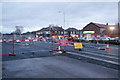
Metrolink construction on Hardy Lane
Construction of the Manchester Airport Metrolink line. This is almost at the point where it crosses Barlow Moor Road. The shops ahead are on Barlow Moor Road.
Image: © Bill Boaden
Taken: 7 Dec 2013
0.14 miles
8
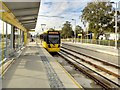
Metrolink Airport Line, Barlow Moor Road Tram Stop
Metrolink tram number 3063 leaves the outbound platform of the Barlow Moor Road tram stop.
This Metrolink stop is in the central reservation of Mauldeth Road West at its junction with Barlow Moor Road. It has two facing platforms for inbound (ie travelling towards Manchester) and outbound (ie travelling towards Manchester Airport) trams.
Image: © David Dixon
Taken: 4 Nov 2014
0.15 miles
9
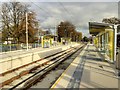
Barlow Moor Road Metrolink Stop, Manchester Airport Line
The Barlow Moor Road Metrolink stop is in the central reservation of Mauldeth Road West at its junction with Barlow Moor Road. It has two facing platforms for inbound (ie travelling towards Manchester) and outbound (ie travelling towards Manchester Airport) trams.
Image: © David Dixon
Taken: 4 Nov 2014
0.15 miles
10
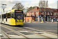
Tram Crossing Barlow Moor Road
Metrolink tram number 3067 crosses Barlow Moor Road as it approaches the Barlow Moor Road tram stop on the route between Manchester Airport and Manchester (Cornbrook).
Image: © David Dixon
Taken: 4 Nov 2014
0.15 miles