IMAGES TAKEN NEAR TO
Rochester Avenue, MANCHESTER, M21 7DE
Introduction
This page details the photographs taken nearby to Rochester Avenue, M21 7DE by members of the Geograph project.
The Geograph project started in 2005 with the aim of publishing, organising and preserving representative images for every square kilometre of Great Britain, Ireland and the Isle of Man.

There are currently over 7.5m images from over14,400 individuals and you can help contribute to the project by visiting https://www.geograph.org.uk
Image Map
Images are licensed for reuse under creativecommons.org/licenses/by-sa/2.0
Notes
- Clicking on the map will re-center to the selected point.
- The higher the marker number, the further away the image location is from the centre of the postcode.
Image Listing (55 Images Found)
Images are licensed for reuse under creativecommons.org/licenses/by-sa/2.0
Image
Details
Distance
1
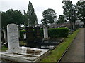
Southern Cemetery, Manchester
The area dedicated to Jewish burials. Barlow Moor Road houses in the distance.
Image: © Eirian Evans
Taken: 8 Aug 2011
0.14 miles
2
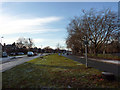
Central reservation on Mauldeth Road West near Chorlton Park
This wide dual carriageway was constructed in the late 1920s, connecting to a widened Hardy Lane, which terminated at Hardy Farm, some way north of the foot crossing over the Mersey at Jackson's Boat. An extension was planned which would have taken Hardy Lane across the river to Sale - this was never constructed. As a result, even today, the road carries much less traffic than it was built to take.
The central reservation was reserved for tram tracks which, as far as I know, were never laid. Trees were later planted instead, mainly planes. These were felled during 2011 to make way for the Metrolink extension towards Manchester Airport, which is to be routed along the centre of the road.
Image: © Phil Champion
Taken: 18 Dec 2011
0.14 miles
3
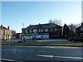
Shops on Mauldeth Road West, Chorlton
The building to the left, on the opposite side of Nell Lane, is the Southern Hotel. All were built in the 1920s, along with the wide dual carriageway. From left to right: Ali Superstore (off licence), a shop with no sign (empty?), and Fish-A-Licious (previously the Southern Friery).
The Metrolink tram line to Manchester airport will be constructed along the central reservation, crossing this view.
Image: © Phil Champion
Taken: 18 Dec 2011
0.14 miles
5
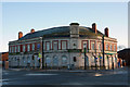
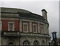
The Southern Hotel, Chorlton
This substantial public house was built in the 1920s at the corner of Mauldeth Road West and Nell Lane. For a number of years the pub had had an Irish theme (there being a large Irish population in the area). According to the signs the building also housed 'Mammy's Irish Kitchen'(a cafe) and the Celtic Tiger nightclub (offering live Irish music). The Southern closed in April 2011 and as of December 2011 was still boarded up and up for sale.
Image: © Phil Champion
Taken: 18 Dec 2011
0.15 miles
6
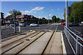
Tram lines on Mauldeth Road West
Part of the Metrolink route to Manchester Airport.
Image: © Bill Boaden
Taken: 10 Jun 2015
0.16 miles
7
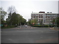
Junction of Nell Lane and Mauldeth Road West, Chorlton
Nell Lane straight ahead; Mauldeth Road West, with the Metrolink branch to Manchester Airport, crosses from left to right.
Image: © Richard Vince
Taken: 12 May 2018
0.16 miles
8
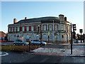
The Southern Hotel, Mauldeth Road West, Chorlton
This substantial public house was built in the 1920s at the corner of Mauldeth Road West and Nell Lane. For a number of years the pub had had an Irish theme (there being a large Irish population in the area). According to the signs the building also housed 'Mammy's Irish Kitchen' (a cafe) and the Celtic Tiger nightclub (offering live Irish music). The Southern closed in April 2011 and as of December 2011 was still boarded up and up for sale.
Image: © Phil Champion
Taken: 18 Dec 2011
0.16 miles
9
Hough End Hall and Mauldeth House
This picture taken from SJ824931 looking North east from Nell Lane. Hough End hall is directly in front and Mauldeth House is to the left of the picture.
Image: © Dave Smethurst
Taken: 5 Sep 2005
0.17 miles
10
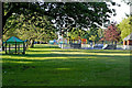
Skate park and teen shelter in Chorlton Park
Image: © Phil Champion
Taken: 25 May 2007
0.17 miles