IMAGES TAKEN NEAR TO
Kings Road, MANCHESTER, M21 0XQ
Introduction
This page details the photographs taken nearby to Kings Road, M21 0XQ by members of the Geograph project.
The Geograph project started in 2005 with the aim of publishing, organising and preserving representative images for every square kilometre of Great Britain, Ireland and the Isle of Man.

There are currently over 7.5m images from over14,400 individuals and you can help contribute to the project by visiting https://www.geograph.org.uk
Image Map
Images are licensed for reuse under creativecommons.org/licenses/by-sa/2.0
Notes
- Clicking on the map will re-center to the selected point.
- The higher the marker number, the further away the image location is from the centre of the postcode.
Image Listing (80 Images Found)
Images are licensed for reuse under creativecommons.org/licenses/by-sa/2.0
Image
Details
Distance
2
Blocks of flats on Wilbraham Road
Privately owned flats.
Image: © Bill Boaden
Taken: 10 Jun 2015
0.09 miles
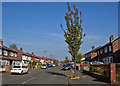
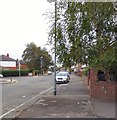
4
Wyverne Road
A residential road like so many others in this area.
Image: © Bill Boaden
Taken: 10 Jun 2015
0.12 miles
5
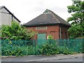
Electricity substation, corner of Egerton Road South & St. Werburgh's Road, Chorlton-cum-Hardy
Tucked away behind a lot of greenery is this electricity substation.
Image: © L S Wilson
Taken: 7 May 2011
0.16 miles
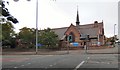
6
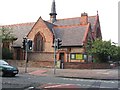
St Werburghs
This is St Werburghs Church on the corner of Wilbraham Road and St Werburghs Road. The picture was taken from SJ823940 looking north.
Image: © Dave Smethurst
Taken: 5 Sep 2005
0.16 miles
7
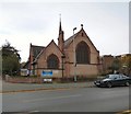
St Werburgh's, Chorlton cum Hardy
The church was founded in 1900. Prior to the Normandy invasion in 1944, St Werburgh's Church Hall was used as a base for US army legal staff billeted in nearby houses before they went over to Germany with the occupation forces to deal with war crimes.
Genuki: http://www.genuki.org.uk/big/eng/LAN/ChorltoncumHardy/StWerburgh
Image: © Gerald England
Taken: 1 Oct 2016
0.16 miles
8
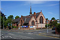
St Werburgh's Church, Chorlton-cum-Hardy
Quite a high Anglican church. Its name is more in the public domain now a tram station is named after the road.
Image: © Bill Boaden
Taken: 10 Jun 2015
0.16 miles
9
Egerton Road South
Off St Werburgh's Road.
Image: © Gerald England
Taken: 1 Oct 2016
0.16 miles
10
St Werburgh's Church
The church was founded in 1900. Prior to the Normandy invasion in 1944, St Werburgh's Church Hall was used as a base for US army legal staff billeted in nearby houses before they went over to Germany with the occupation forces to deal with war crimes.
Genuki: http://www.genuki.org.uk/big/eng/LAN/ChorltoncumHardy/StWerburgh
Image: © Gerald England
Taken: 1 Oct 2016
0.17 miles