IMAGES TAKEN NEAR TO
Marchwood Avenue, MANCHESTER, M21 0TZ
Introduction
This page details the photographs taken nearby to Marchwood Avenue, M21 0TZ by members of the Geograph project.
The Geograph project started in 2005 with the aim of publishing, organising and preserving representative images for every square kilometre of Great Britain, Ireland and the Isle of Man.

There are currently over 7.5m images from over14,400 individuals and you can help contribute to the project by visiting https://www.geograph.org.uk
Image Map
Images are licensed for reuse under creativecommons.org/licenses/by-sa/2.0
Notes
- Clicking on the map will re-center to the selected point.
- The higher the marker number, the further away the image location is from the centre of the postcode.
Image Listing (7 Images Found)
Images are licensed for reuse under creativecommons.org/licenses/by-sa/2.0
Image
Details
Distance
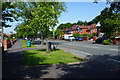
1
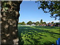
St Bede's College Playing Field, Withington Road
The playing field has been used for St Bede's College pupils for perhaps 100 years. The Pavilion is at the far side of the field.
Image: © Tom Jolliffe
Taken: 30 Sep 2016
0.12 miles
2
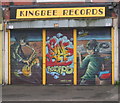
KingBee Records, Wilbraham Road, Chorlton
King Bee sell some brand new stuff and a vast array of varying styles of second hand vinyl and CD's. It can get cramped in there at times, but it's worth it because you'll find a bargain every now and again.
Image: © Paul Ashwin
Taken: 16 Apr 2005
0.16 miles
3
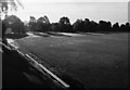
St Bede's College Sports Ground, Brantingham Road
This photograph taken from the Pavilion on the Sports Ground in the early morning shows Withington Road beyond the trees.
Image: © Tom Jolliffe
Taken: Unknown
0.17 miles
4
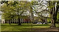
The British Muslim Heritage Centre
The British Muslim Heritage Centre based in what was Lancashire Independent College.
The Lancashire Independent College was originally built in 1840-43 as a college for the training of non-conformist ministers. It was designed by Irwin and Chester in a Gothic style with the wings rebuilt to three storeys and the hall added in the late 1870s. It was built to provide higher education for nonconformists who were excluded from the Universities of Oxford and Cambridge until 1871.
Image: © Peter McDermott
Taken: 2 May 2021
0.22 miles
6
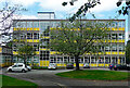
School, Withington Road, Manchester
A well-preserved 1960s building.
Now St Margaret's Church of England Primary School.
Image: © Stephen Richards
Taken: 17 Aug 2016
0.24 miles
7
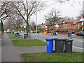
Wilbraham Road
A very long route almost entirely lined by residential properties. In this area not far off Chorlton, the houses are a bit newer than most.
Image: © Bill Boaden
Taken: 10 Jun 2015
0.25 miles