IMAGES TAKEN NEAR TO
Westfield Road, MANCHESTER, M21 0SP
Introduction
This page details the photographs taken nearby to Westfield Road, M21 0SP by members of the Geograph project.
The Geograph project started in 2005 with the aim of publishing, organising and preserving representative images for every square kilometre of Great Britain, Ireland and the Isle of Man.

There are currently over 7.5m images from over14,400 individuals and you can help contribute to the project by visiting https://www.geograph.org.uk
Image Map
Images are licensed for reuse under creativecommons.org/licenses/by-sa/2.0
Notes
- Clicking on the map will re-center to the selected point.
- The higher the marker number, the further away the image location is from the centre of the postcode.
Image Listing (54 Images Found)
Images are licensed for reuse under creativecommons.org/licenses/by-sa/2.0
Image
Details
Distance
1
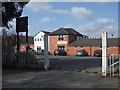
South West Manchester Cricket Club
The entrance and pavilion at South West Manchester CC. the club run three teams in the Manchester & District Cricket Association.
Image: © BatAndBall
Taken: 25 Mar 2013
0.11 miles
2
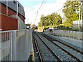
Metrolink to Manchester
The tramline to Manchester from the end of the platform at Chorlton.
Image: © Gerald England
Taken: 3 Oct 2012
0.13 miles
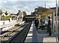
3

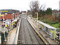
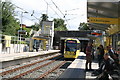
Chorlton Metrolink Station
Passengers leave Metrolink tram number 3001 at Chorlton Station.
Image: © David Dixon
Taken: 25 Feb 2013
0.14 miles
4
Chorlton-cum-Hardy railway station (site), Greater Manchester
Opened in 1880 by the Midland Railway on the line from Chinley to Manchester Central, this station closed in 1967. The station was rebuilt and reopened on the same site in 2011 as part of Manchester Metrolink.
View north west towards Firswood tram stop and Manchester.
Image: © Nigel Thompson
Taken: 30 Dec 2013
0.14 miles
5
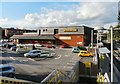
Chorlton Morrisons and Metrolink Station
The Chorlton Morrisons store from the steps leading down to Chorlton Metrolink Station. The store was built on the site of the original Chorlton-cum-Hardy railway station. http://www.disused-stations.org.uk/c/chorlton_cum_hardy/
Image: © Gerald England
Taken: 3 Oct 2012
0.15 miles
6
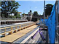
Chorlton cum Hardy Metrolink station
The as yet unfinished Metrolink station, looking towards Didsbury. The station is due to open in spring 2011, with trams going to Oldham and Rochdale via Manchester.
Image: © Paddy Griffin
Taken: 16 Aug 2010
0.15 miles
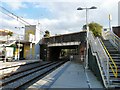
7
Chorlton Metrolink Station
Morrison's now have a medium-sized store next to the station.
Image: © Bill Boaden
Taken: 7 Dec 2013
0.15 miles
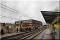
8
Chorlton Station
Metrolink station on the line to St Werburgh's Road (and eventually to East Didsbury).
Image: © Gerald England
Taken: 3 Oct 2012
0.15 miles
9
Chorlton Metrolink station
On the line, initially to St Werburgh's Road but planned for extension to East Didsbury.
Image: © Gerald England
Taken: 3 Oct 2012
0.15 miles
10
Chorlton: Metrolink station
Tram No 3105 approaches with a service for Shaw. It will use the Second City Crossing via Exchange Square.
Image: © Dr Neil Clifton
Taken: 2 Aug 2017
0.15 miles