IMAGES TAKEN NEAR TO
Warwick Road, MANCHESTER, M21 0AX
Introduction
This page details the photographs taken nearby to Warwick Road, M21 0AX by members of the Geograph project.
The Geograph project started in 2005 with the aim of publishing, organising and preserving representative images for every square kilometre of Great Britain, Ireland and the Isle of Man.

There are currently over 7.5m images from over14,400 individuals and you can help contribute to the project by visiting https://www.geograph.org.uk
Image Map
Images are licensed for reuse under creativecommons.org/licenses/by-sa/2.0
Notes
- Clicking on the map will re-center to the selected point.
- The higher the marker number, the further away the image location is from the centre of the postcode.
Image Listing (71 Images Found)
Images are licensed for reuse under creativecommons.org/licenses/by-sa/2.0
Image
Details
Distance
1
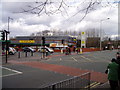
Morrisons Supermarket in Chorlton cum Hardy
On the corner of Wilbraham Road and Albany Road, Morrisons supermarket in Chorlton cum Hardy is the main supermarket serving the area.
Image: © R Greenhalgh
Taken: 7 Mar 2008
0.07 miles
4
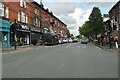
Shops on the north side of Wilbraham Road, Chorlton
Originally a row of three storey houses with front gardens, the gardens were in-filled more than a century ago with single storey shops. Some of the original detailing still remains, but most of the shop fronts are modern.
Image: © Phil Champion
Taken: 20 Apr 2014
0.07 miles
5
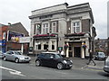
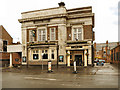
Royal Oak, Barlow Moor Road, Manchester
Fancy brick and terracotta pub, now a Greene King but previously a Threlfalls pub as evidenced by the parapet lettering.
Image: © Stephen Richards
Taken: 27 May 2016
0.07 miles
6
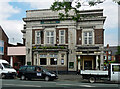
The Royal Oak
The Royal Oak public house on Manchester Road, Chorlton-Cum-Hardy
Image: © David Dixon
Taken: 12 Jun 2011
0.07 miles
7
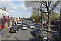
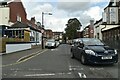
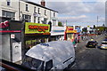
Wilbraham Road, Chorlton
Looking east towards the junction with Albany and Corkland Roads from the top deck of the 85 bus. The white buildings on the left were once private residence with long front gardens, before the addition of single storey shops in front.
Image: © Phil Champion
Taken: 19 Apr 2014
0.07 miles
8
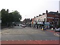
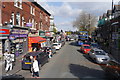
Road Junction
This is the view down Wilbraham Road from the railway bridge approaching the junction with albany and Corkland roads. Taken from SJ818940 facing west.
Image: © Dave Smethurst
Taken: 5 Sep 2005
0.07 miles