IMAGES TAKEN NEAR TO
Pine Road, MANCHESTER, M20 6UY
Introduction
This page details the photographs taken nearby to Pine Road, M20 6UY by members of the Geograph project.
The Geograph project started in 2005 with the aim of publishing, organising and preserving representative images for every square kilometre of Great Britain, Ireland and the Isle of Man.

There are currently over 7.5m images from over14,400 individuals and you can help contribute to the project by visiting https://www.geograph.org.uk
Image Map
Images are licensed for reuse under creativecommons.org/licenses/by-sa/2.0
Notes
- Clicking on the map will re-center to the selected point.
- The higher the marker number, the further away the image location is from the centre of the postcode.
Image Listing (70 Images Found)
Images are licensed for reuse under creativecommons.org/licenses/by-sa/2.0
Image
Details
Distance
1
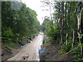
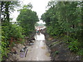
View from Elm Road Bridge
Looking south-southeast. The former railway cutting which is being utilised as part of the Manchester Metrolink extension to East Didsbury, due for completion in Summer 2013. It was raining quite steadily and, as can be seen, I was having a slight problem keeping the camera lens dry.
Image: © Stephen Armstrong
Taken: 18 Jul 2011
0.03 miles
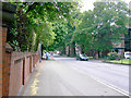
2
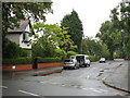
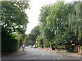
Pine Road
Viewed from Elm Road. There are some lovely large houses in this area, and many large trees also.
Image: © Stephen Armstrong
Taken: 18 Jul 2011
0.05 miles
3
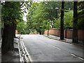
Elm Road Bridge
No longer a bridge over the railway, but will be a bridge over the Manchester Metrolink when the extension to East Didsbury is completed in 2013.
Image: © Stephen Armstrong
Taken: 18 Jul 2011
0.05 miles
4
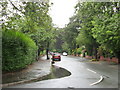
Elm Road
Looking south west from Pine Road. As can be seen from the puddles, it had been raining quite heavily, and still was raining steadily.
Image: © Stephen Armstrong
Taken: 18 Jul 2011
0.07 miles
5
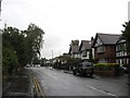
Elm Road, West Didsbury
In a leafy residential suburb.
Image: © philandju
Taken: 19 Sep 2017
0.07 miles
6
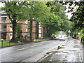
Lapwing Lane
Looking towards the junction with Wilmslow Road.
Image: © Stephen Armstrong
Taken: 18 Jul 2011
0.07 miles
7
View from Elm Road Bridge
Looking north-northwest towards Palatine Road bridge. The former railway cutting which is being utilised as part of the Manchester Metrolink extension to East Didsbury, due for completion in Summer 2013.
Image: © Stephen Armstrong
Taken: 18 Jul 2011
0.08 miles
8
Lapwing Lane
Looking northwest towards Palatine Road, on a miserable wet day.
Image: © Stephen Armstrong
Taken: 18 Jul 2011
0.10 miles
9
Lapwing Lane, Manchester
Taken from just past the Lyndhurst Road corner, looking south east towards Wilmslow Road (not visible in the photograph). Lapwing Lane is nearing its end here - it becomes Fog Lane after crossing Wilmslow Road.
Image: © Slbs
Taken: Unknown
0.10 miles
10

Wilmslow Road junction Fog Lane/Lapwing Lane
Image: © Peter Turner
Taken: 21 May 2012
0.10 miles