IMAGES TAKEN NEAR TO
Northenden View, MANCHESTER, M20 6UD
Introduction
This page details the photographs taken nearby to Northenden View, M20 6UD by members of the Geograph project.
The Geograph project started in 2005 with the aim of publishing, organising and preserving representative images for every square kilometre of Great Britain, Ireland and the Isle of Man.

There are currently over 7.5m images from over14,400 individuals and you can help contribute to the project by visiting https://www.geograph.org.uk
Image Map
Images are licensed for reuse under creativecommons.org/licenses/by-sa/2.0
Notes
- Clicking on the map will re-center to the selected point.
- The higher the marker number, the further away the image location is from the centre of the postcode.
Image Listing (202 Images Found)
Images are licensed for reuse under creativecommons.org/licenses/by-sa/2.0
Image
Details
Distance
1
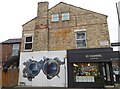
Hark the Herald Angels Sing
So says the sign in the window of optician's Jo Padmore on South Road Image On the gable wall is a mural by Qubek.
Image: © Gerald England
Taken: 1 Dec 2022
0.06 miles
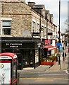
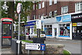
2
Postbox, Wilmslow Road, Didsbury
Postbox number M20 602D, on the corner of Grove Lane.
Image: © Robin Stott
Taken: 17 Jul 2010
0.07 miles
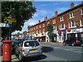
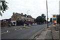
3
South Road, Didsbury
A group of shops at the corner of South Road and Wilmslow Road, Didsbury.
Image: © Gerald England
Taken: 8 Apr 2010
0.07 miles
4
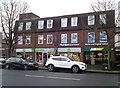
Oxfam, Didsbury
Before 2008 Oxfam just had the middle of three ground floor units to the left of "Subway". Between Oxfam and Subway was David Plick, bookmakers. By 2014 Oxfam had expanded into the corner unit and the bookmakers was a charity shop for Shelter. In 2018 Oxfam expanded again taking all three units. The offices above have now been occupied by Explore Learning.
Image: © Gerald England
Taken: 17 Jan 2020
0.07 miles
5
A Walk in Didsbury Village (88) Shell Garage and shops opposite
Today's fuel price at the Shell garage. The pavement is not so good here...The terrace of shops ending at South Road is constructed in those cream coloured bricks which were sometimes used in Manchester's outlying districts. These might be the only building using them in Didsbury village?
Image: © Tom Jolliffe
Taken: 20 Jul 2023
0.07 miles
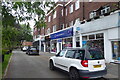
6
A Walk in Didsbury Village (45) Lansdowne House
West side Good to see a telephone box still in existence. This row of shops, (included in Lansdowne House), which might once have been described as a "parade" is set back from the main road and allows parking. It was probably built in the 1940s/50s and clearly includes residential accommodation. Some charity shops are evident. The large tree may be an acacia from the leaves, but these are notorious for growing from "suckers" and spreading, so I am doubtful. There are variegated holly trees in the containers.
Image: © Tom Jolliffe
Taken: 20 Jul 2023
0.07 miles
7
A Walk in Didsbury Village (49) Lansdowne House
Another view of Lansdowne House off the main road pavement. Further down the row of shops is a Nail care shop, there was another further back.
Image: © Tom Jolliffe
Taken: 20 Jul 2023
0.07 miles
8
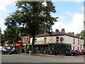
The Crown, Didsbury
Public house on Wilmslow Road.
Image: © philandju
Taken: 14 Sep 2017
0.07 miles
9
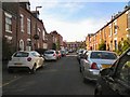
Whitechapel Street
Suburban terraced housing in Didsbury.
Image: © Gerald England
Taken: 1 Oct 2011
0.07 miles
10
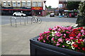
A Walk in Didsbury Village (94) Didsbury in Bloom Planted Container
The pavement at the corner of Grange Lane and Wilmslow Road is exceptionally wide. Another of the planted containers for Didsbury in Bloom is full of begonia flowers. A pushbike is secured to a security hoop opposite to Wing Hing on the other side of Wilmslow Road.
Image: © Tom Jolliffe
Taken: 20 Jul 2023
0.07 miles