IMAGES TAKEN NEAR TO
Melrose Avenue, MANCHESTER, M20 6SS
Introduction
This page details the photographs taken nearby to Melrose Avenue, M20 6SS by members of the Geograph project.
The Geograph project started in 2005 with the aim of publishing, organising and preserving representative images for every square kilometre of Great Britain, Ireland and the Isle of Man.

There are currently over 7.5m images from over14,400 individuals and you can help contribute to the project by visiting https://www.geograph.org.uk
Image Map
Images are licensed for reuse under creativecommons.org/licenses/by-sa/2.0
Notes
- Clicking on the map will re-center to the selected point.
- The higher the marker number, the further away the image location is from the centre of the postcode.
Image Listing (37 Images Found)
Images are licensed for reuse under creativecommons.org/licenses/by-sa/2.0
Image
Details
Distance
2
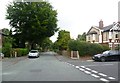
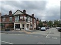
Chiswick Road, Didsbury
Red-brick terraces.
Image: © Bill Boaden
Taken: 13 Apr 2012
0.13 miles
3
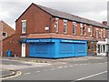
Violin maker and restorer on School Lane
Image: © Graham Hogg
Taken: 3 Sep 2020
0.13 miles
5
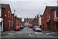
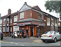
Dundonald Road, Didsbury
Urban for hair, nails and beauty
Image: © Chris Morgan
Taken: 3 Sep 2020
0.18 miles
6
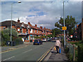
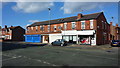
School Lane, Didsbury
Looking east. The yellow sign advises: Diversion | Trans-Pennine | Trail (East) | Stockport.
Image: © Robin Stott
Taken: 17 Jul 2010
0.18 miles
7
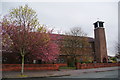
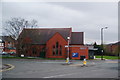
St Catherine of Siena RC Church
The appearance of the brick building is improved by the spring trees.
Image: © Bill Boaden
Taken: 13 Apr 2012
0.18 miles
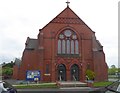
9
Didsbury Baptist Church
On the junction of Beaver Road with School Lane.
Image: © Bill Boaden
Taken: 13 Apr 2012
0.20 miles
10
Didsbury Baptist Church
On Beaver Road
Image: © Eirian Evans
Taken: 10 May 2015
0.21 miles