IMAGES TAKEN NEAR TO
Adria Road, MANCHESTER, M20 6SG
Introduction
This page details the photographs taken nearby to Adria Road, M20 6SG by members of the Geograph project.
The Geograph project started in 2005 with the aim of publishing, organising and preserving representative images for every square kilometre of Great Britain, Ireland and the Isle of Man.

There are currently over 7.5m images from over14,400 individuals and you can help contribute to the project by visiting https://www.geograph.org.uk
Image Map
Images are licensed for reuse under creativecommons.org/licenses/by-sa/2.0
Notes
- Clicking on the map will re-center to the selected point.
- The higher the marker number, the further away the image location is from the centre of the postcode.
Image Listing (45 Images Found)
Images are licensed for reuse under creativecommons.org/licenses/by-sa/2.0
Image
Details
Distance
2
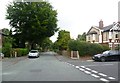
Sussex Avenue, Didsbury
Houses in a pleasant street which runs down to Fog Lane Park.
Image: © David Hawgood
Taken: 22 Oct 2005
0.16 miles
3
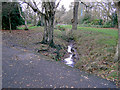
Ball Brook, Fog Lane Park
Ball Brook is little more than a muddy ditch.
Image: © Slbs
Taken: Unknown
0.16 miles
4

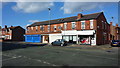
Violin maker and restorer on School Lane
Image: © Graham Hogg
Taken: 3 Sep 2020
0.17 miles
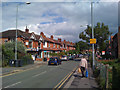
5
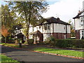
Chiswick Road, Didsbury
Red-brick terraces.
Image: © Bill Boaden
Taken: 13 Apr 2012
0.18 miles
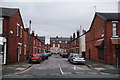
7
School Lane, Didsbury
Looking east. The yellow sign advises: Diversion | Trans-Pennine | Trail (East) | Stockport.
Image: © Robin Stott
Taken: 17 Jul 2010
0.19 miles
8
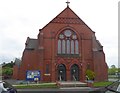
Didsbury Baptist Church
On Beaver Road
Image: © Eirian Evans
Taken: 10 May 2015
0.19 miles
9
Didsbury Baptist Church
On the junction of Beaver Road with School Lane.
Image: © Bill Boaden
Taken: 13 Apr 2012
0.19 miles
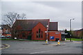
10
Fog Lane Park
Open space, much favoured by dog walkers in Fog Lane Park
Image: © Chris Heaton
Taken: 25 Jan 2016
0.20 miles