IMAGES TAKEN NEAR TO
Kingsway, MANCHESTER, M20 5WR
Introduction
This page details the photographs taken nearby to Kingsway, M20 5WR by members of the Geograph project.
The Geograph project started in 2005 with the aim of publishing, organising and preserving representative images for every square kilometre of Great Britain, Ireland and the Isle of Man.

There are currently over 7.5m images from over14,400 individuals and you can help contribute to the project by visiting https://www.geograph.org.uk
Image Map
Images are licensed for reuse under creativecommons.org/licenses/by-sa/2.0
Notes
- Clicking on the map will re-center to the selected point.
- The higher the marker number, the further away the image location is from the centre of the postcode.
Image Listing (16 Images Found)
Images are licensed for reuse under creativecommons.org/licenses/by-sa/2.0
Image
Details
Distance
1
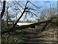
Riverside path going under A34
By the River Mersey, in East Didsbury, south of Manchester.Fallen tree crosses the path.
Image: © Peter Barr
Taken: 27 Feb 2013
0.08 miles
2
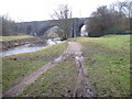
Rail bridge over River Mersey South of East Didsbury
Image: © Chris Wimbush
Taken: 20 Jan 2011
0.08 miles
3
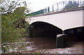
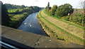
Kingsway bridge, Didsbury
This crossing of the Mersey was opened in 1959. The Cheadle Road bridge (in the same square) was until then the only crossing point between Stockport and Northenden, and was infamous for many postwar years for the "Cheadle Crawl" - an every day rush-hour traffic jam which had delayed motorists commuting into Manchester (and going home).
Image: © S Parish
Taken: 24 Oct 2005
0.10 miles
5
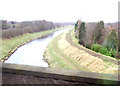
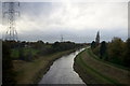
The River Mersey
Viewed from a train from Manchester Airport to Blackpool North.
Image: © Thomas Nugent
Taken: 19 Oct 2018
0.15 miles
6
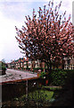
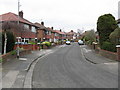
Mellington Avenue, East Didsbury
Typical 1930s suburban housing.
Image: © Peter Ward
Taken: Unknown
0.15 miles
7
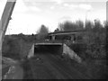
Railway North of Gatley
The road over the railway line is the A34 (Kingsway); the flyover section behind is the slip road from the M60 motorway at junction 3.
Image: © David Dixon
Taken: 2 Nov 2012
0.18 miles
9
River Mersey at Gatley
From the rail line into Manchester.
Image: © Mike Pennington
Taken: 12 Nov 2015
0.21 miles
10
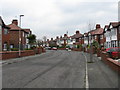
East Didsbury - Broughville Drive
Typical housing of this area which grew up along the "Styal Loop" railway line.
Image: © Peter Whatley
Taken: 31 Mar 2009
0.22 miles