IMAGES TAKEN NEAR TO
Broad Oak Lane, MANCHESTER, M20 5GA
Introduction
This page details the photographs taken nearby to Broad Oak Lane, M20 5GA by members of the Geograph project.
The Geograph project started in 2005 with the aim of publishing, organising and preserving representative images for every square kilometre of Great Britain, Ireland and the Isle of Man.

There are currently over 7.5m images from over14,400 individuals and you can help contribute to the project by visiting https://www.geograph.org.uk
Image Map
Images are licensed for reuse under creativecommons.org/licenses/by-sa/2.0
Notes
- Clicking on the map will re-center to the selected point.
- The higher the marker number, the further away the image location is from the centre of the postcode.
Image Listing (8 Images Found)
Images are licensed for reuse under creativecommons.org/licenses/by-sa/2.0
Image
Details
Distance
1
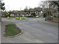
East Didsbury - Parrs Wood Road southern end
This lengthy through route fizzles out amongst suburban housing at the junction ahead. Plans to extend through to Sharston across the River Mersey were shelved many years ago.
Image: © Peter Whatley
Taken: 31 Mar 2009
0.17 miles

3
River Mersey at Gatley
From the rail line into Manchester.
Image: © Mike Pennington
Taken: 12 Nov 2015
0.22 miles
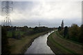
4
River Mersey
Approaching a point where the electricity transmission wires cross the banks of the river
Image: © Kevin Waterhouse
Taken: 26 Jun 2023
0.23 miles
5

Mellington Avenue, East Didsbury
Typical 1930s suburban housing.
Image: © Peter Ward
Taken: Unknown
0.23 miles
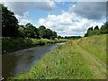
7

The River Mersey
Viewed from a train from Manchester Airport to Blackpool North.
Image: © Thomas Nugent
Taken: 19 Oct 2018
0.25 miles
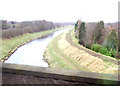
8
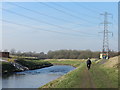
Cyclist on Trans Pennine Trail
By the River Mersey, in East Didsbury, approaching the Didsbury Sluice Station, finely adorned by painters. Pylons carry power lines over the river.
Image: © Peter Barr
Taken: 27 Feb 2013
0.25 miles