IMAGES TAKEN NEAR TO
Francis Road, MANCHESTER, M20 4XP
Introduction
This page details the photographs taken nearby to Francis Road, M20 4XP by members of the Geograph project.
The Geograph project started in 2005 with the aim of publishing, organising and preserving representative images for every square kilometre of Great Britain, Ireland and the Isle of Man.

There are currently over 7.5m images from over14,400 individuals and you can help contribute to the project by visiting https://www.geograph.org.uk
Image Map
Images are licensed for reuse under creativecommons.org/licenses/by-sa/2.0
Notes
- Clicking on the map will re-center to the selected point.
- The higher the marker number, the further away the image location is from the centre of the postcode.
Image Listing (23 Images Found)
Images are licensed for reuse under creativecommons.org/licenses/by-sa/2.0
Image
Details
Distance
1
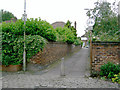
Ginnel at the end of Henwood Road, Withington
Between Henwood Road and Parkville Road (glimpsed in the distance), the ginnel is a useful shortcut to Fog Lane Park.
Image: © Slbs
Taken: Unknown
0.06 miles
4
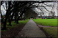
Footpath in Fog Lane Park
Part of the perimeter path in Fog Lane Park
Image: © Chris Heaton
Taken: 25 Jan 2016
0.10 miles
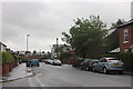
5
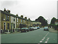
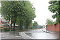
Cotton Lane, Withington
Taken from its junction with Stephens Road (seen in the right foreground).
Image: © Slbs
Taken: Unknown
0.14 miles
6
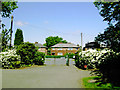
Entrance to Fog Lane Park, Manchester
This entrance is on the north side of the park - the photograph was taken from inside the park looking north. The road running along the park's north side is Parkville Road.
Image: © Slbs
Taken: Unknown
0.15 miles
7
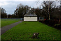
Pavilion in Fog Lane Park - Side View
Heavily fortified against vandalism
Image: © Chris Heaton
Taken: 25 Jan 2016
0.15 miles
8
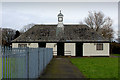
Pavilion in Fog Lane Park - Frontage
Heavily secured with padlocks, caged windows and shuttered doors to prevent vandalism.
The Bowling Green, to the left, is also surrounded by galvanised fencing with sharp pointed crowns.
Image: © Chris Heaton
Taken: 25 Jan 2016
0.16 miles
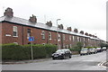
9
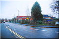
Cotton Lane/Heyscroft Road junction
Buildings to the left are St Cuthbert's Primary School.
Image: © Peter Turner
Taken: 31 May 2012
0.16 miles
10
St Cuthbert's RC Primary School, Withington
The entrance is further along Heyscroft Road, though it also backs onto Cotton Lane to the right.
Image: © Bill Boaden
Taken: 27 Dec 2012
0.17 miles