IMAGES TAKEN NEAR TO
School Grove, MANCHESTER, M20 4RT
Introduction
This page details the photographs taken nearby to School Grove, M20 4RT by members of the Geograph project.
The Geograph project started in 2005 with the aim of publishing, organising and preserving representative images for every square kilometre of Great Britain, Ireland and the Isle of Man.

There are currently over 7.5m images from over14,400 individuals and you can help contribute to the project by visiting https://www.geograph.org.uk
Image Map
Images are licensed for reuse under creativecommons.org/licenses/by-sa/2.0
Notes
- Clicking on the map will re-center to the selected point.
- The higher the marker number, the further away the image location is from the centre of the postcode.
Image Listing (15 Images Found)
Images are licensed for reuse under creativecommons.org/licenses/by-sa/2.0
Image
Details
Distance
1
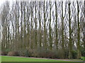
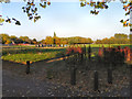
Ladybarn Park
A Poplar corner of Ladybarn Park, Withington.
Image: © David Seale
Taken: 24 Mar 2006
0.10 miles
2
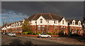
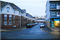
Withington
New development of houses in Withington.
Image: © Peter McDermott
Taken: 1 Nov 2014
0.10 miles
5
Whimberry Way, Burnage
A street of new apartments next to Ladybarn Park.
Image: © Bill Boaden
Taken: 27 Dec 2012
0.13 miles
8
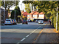
Fairholme Road, Withington
Taken from near its junction with Parsonage Road, looking south.
Image: © Slbs
Taken: Unknown
0.15 miles
9
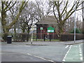
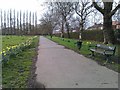
Ladybarn Park, Withington.
The entrance to Ladybarn Park on Parrswood Rd
Image: © David Seale
Taken: 24 Mar 2006
0.18 miles
10
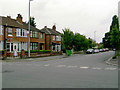
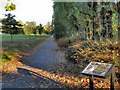
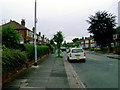
School Grove, Withington
Taken from Fairholme Road (seen running across the foreground).
Image: © Slbs
Taken: Unknown
0.18 miles