IMAGES TAKEN NEAR TO
Cotton Lane, MANCHESTER, M20 4GL
Introduction
This page details the photographs taken nearby to Cotton Lane, M20 4GL by members of the Geograph project.
The Geograph project started in 2005 with the aim of publishing, organising and preserving representative images for every square kilometre of Great Britain, Ireland and the Isle of Man.

There are currently over 7.5m images from over14,400 individuals and you can help contribute to the project by visiting https://www.geograph.org.uk
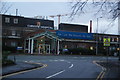
Image Map
Images are licensed for reuse under creativecommons.org/licenses/by-sa/2.0
Notes
- Clicking on the map will re-center to the selected point.
- The higher the marker number, the further away the image location is from the centre of the postcode.
Image Listing (61 Images Found)
Images are licensed for reuse under creativecommons.org/licenses/by-sa/2.0
Image
Details
Distance
1
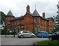
The Grange, Wilmslow Road, Manchester
A spacious former villa built around 1870 for Max Baerlin, a cotton-spinner and dyer.
Now a school.
Image: © Stephen Richards
Taken: 27 May 2016
0.07 miles
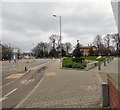
2
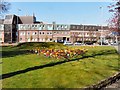
Flowerbeds opposite Christie Hospital
In the triangle between Cotton Lane, Kinnaird Road and Wilmslow Road.
Image: © Gerald England
Taken: 22 Apr 2010
0.07 miles
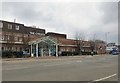
3
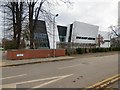
Manchester Cancer Research Centre
Opposite the main entrance to The Christie on Wilmslow Road Image is the Manchester Cancer Research Centre Image The new MCRC building, between Kinnaird Road and Cotton Lane was completed in 2015 and brings together 150 laboratory-based scientists from The University of Manchester and the Cancer Research UK Manchester Institute and is also home to clinical trials support staff and cancer clinicians. http://www.mcrc.manchester.ac.uk/About/History-and-Achievements
Image: © Gerald England
Taken: 11 Mar 2017
0.07 miles
4
Manchester Cancer Research Centre
Opposite the main entrance to The Christie on Wilmslow Road is the Manchester Cancer Research Centre. The new MCRC building, between Kinnaird Road and Cotton Lane was completed in 2015 and brings together 150 laboratory-based scientists from The University of Manchester and the Cancer Research UK Manchester Institute and is also home to clinical trials support staff and cancer clinicians. http://www.mcrc.manchester.ac.uk/About/History-and-Achievements
Image: © Gerald England
Taken: 11 Mar 2017
0.07 miles
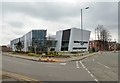
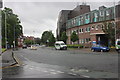
5
Wilmslow Road
The B5093 from Didsbury. On the left is The Christie Image On the right is the Manchester Cancer Research Centre Image
Image: © Gerald England
Taken: 11 Mar 2017
0.08 miles
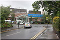
6
The Christie
The main entrance to The Christie on Wilmslow Road Image
The Christie is the largest cancer treatment centre of its kind in Europe and an international leader in research and development. It has been located here since 1932 but its origins go back to the turn of the 20th century.
For more information on its history see Wikipedia https://en.wikipedia.org/wiki/Christie_NHS_Foundation_Trust and for up to date information see the hospital's site http://www.christie.nhs.uk/
Image: © Gerald England
Taken: 11 Mar 2017
0.09 miles
7
Christie Hospital/Holt Radium Institute, Wilmslow Road
The substantial block contains facilities from basic research, through testing new procedures and treatments to full specialised care of patients with all forms of cancer.
Image: © Peter Turner
Taken: 31 May 2012
0.09 miles
8
The Christie Hospital, Wilmslow Road entrance
Image: © Peter Turner
Taken: 31 May 2012
0.10 miles
9
Christie Hospital, Withington
One of the top cancer hospitals. Most people go in the southern end where the car park is.
Image: © Bill Boaden
Taken: 27 Dec 2012
0.10 miles
10
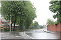
Cotton Lane/Heyscroft Road junction
Buildings to the left are St Cuthbert's Primary School.
Image: © Peter Turner
Taken: 31 May 2012
0.11 miles