IMAGES TAKEN NEAR TO
Ferngate Drive, MANCHESTER, M20 4AH
Introduction
This page details the photographs taken nearby to Ferngate Drive, M20 4AH by members of the Geograph project.
The Geograph project started in 2005 with the aim of publishing, organising and preserving representative images for every square kilometre of Great Britain, Ireland and the Isle of Man.

There are currently over 7.5m images from over14,400 individuals and you can help contribute to the project by visiting https://www.geograph.org.uk
Image Map
Images are licensed for reuse under creativecommons.org/licenses/by-sa/2.0
Notes
- Clicking on the map will re-center to the selected point.
- The higher the marker number, the further away the image location is from the centre of the postcode.
Image Listing (111 Images Found)
Images are licensed for reuse under creativecommons.org/licenses/by-sa/2.0
Image
Details
Distance
2

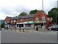
Wilmslow Road
The B5093 passing Christies Hospital. Opposite the hospital is an undertakers and several cafes or takeaways.
Image: © Gerald England
Taken: 18 Dec 2021
0.06 miles
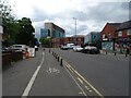
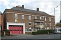
4

Wilmslow Road and Withington Community Fire Station
Image: © David Smith
Taken: 24 Oct 2019
0.06 miles
5

Sign for the Red Lion, Withington, Manchester M20
Image: © JThomas
Taken: 30 May 2024
0.06 miles
6

The Grange, Wilmslow Road, Manchester
A spacious former villa built around 1870 for Max Baerlin, a cotton-spinner and dyer.
Now a school.
Image: © Stephen Richards
Taken: 27 May 2016
0.06 miles
7
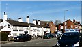
Red Lion
The Red Lion on Wilmslow Road, Withington.
Image: © Gerald England
Taken: 22 Apr 2010
0.07 miles
8
Withington fire station
Withington fire station, 505-507 Wilmslow Road, Withington, Greater Manchester
Image: © Kevin Hale
Taken: 30 Oct 2007
0.07 miles
9

Old Milestone by the B5093, Wilmslow Road, Manchester
Carved stone post by the B5093, in parish of MANCHESTER (MANCHESTER District), Wilmslow Road; by Fire Station Flats, No. 507, in hedge niche, on East side of road. Wilmslow triangle, erected by the Wilmslow turnpike trust in the 19th century.
Inscription reads:-
: 8¼ / Miles to / Wilmslow : : Withington : : 4 / Miles to / Manchester / to / Centre of / St. Anns / Square :
Grade II listed.
List Entry Number: 1415631 https://historicengland.org.uk/listing/the-list/list-entry/1415631
Milestone Society National ID: LA_MAWM04
Image: © Mike Faherty
Taken: 26 Jan 2009
0.07 miles