IMAGES TAKEN NEAR TO
Mauldeth Road West, MANCHESTER, M20 3FQ
Introduction
This page details the photographs taken nearby to Mauldeth Road West, M20 3FQ by members of the Geograph project.
The Geograph project started in 2005 with the aim of publishing, organising and preserving representative images for every square kilometre of Great Britain, Ireland and the Isle of Man.

There are currently over 7.5m images from over14,400 individuals and you can help contribute to the project by visiting https://www.geograph.org.uk
Image Map
Images are licensed for reuse under creativecommons.org/licenses/by-sa/2.0
Notes
- Clicking on the map will re-center to the selected point.
- The higher the marker number, the further away the image location is from the centre of the postcode.
Image Listing (37 Images Found)
Images are licensed for reuse under creativecommons.org/licenses/by-sa/2.0
Image
Details
Distance
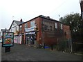
1
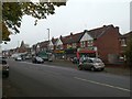
Row of shops, Mauldeth Road West
Before most people had cars, this must have been a thriving row of shops
Image: © David Smith
Taken: 24 Oct 2019
0.01 miles
6
Ghost sign (advert), Mauldeth Road West
A ghost advertisement for Gold Flake cigarettes
Image: © David Smith
Taken: 24 Oct 2019
0.06 miles
7
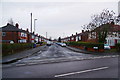
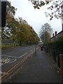
Delacourt Road
Typical residential road of the area.
Image: © Bill Boaden
Taken: 27 Dec 2012
0.10 miles