IMAGES TAKEN NEAR TO
Northbank Walk, MANCHESTER, M20 2YH
Introduction
This page details the photographs taken nearby to Northbank Walk, M20 2YH by members of the Geograph project.
The Geograph project started in 2005 with the aim of publishing, organising and preserving representative images for every square kilometre of Great Britain, Ireland and the Isle of Man.

There are currently over 7.5m images from over14,400 individuals and you can help contribute to the project by visiting https://www.geograph.org.uk
Image Map
Images are licensed for reuse under creativecommons.org/licenses/by-sa/2.0
Notes
- Clicking on the map will re-center to the selected point.
- The higher the marker number, the further away the image location is from the centre of the postcode.
Image Listing (34 Images Found)
Images are licensed for reuse under creativecommons.org/licenses/by-sa/2.0
Image
Details
Distance
1
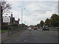
Manchester : Princess Road A5103
Looking along the road as it heads into the City of Manchester.
Image: © Lewis Clarke
Taken: 11 Oct 2014
0.06 miles
2
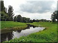
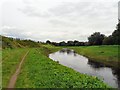
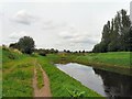
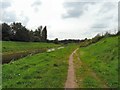
River Mersey
Here the Trans Pennine Trail follows the northern bank of the River Mersey. On the right are playing fields. A cycletrack follows the southern bank. Behind the trees is Northenden golf course.
Image: © Gerald England
Taken: 21 Jul 2012
0.07 miles
3
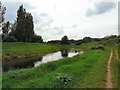
River Mersey
Here the Trans Pennine Trail follows the northern bank of the River Mersey. On the right are playing fields. A cycletrack follows the southern bank. Behind the trees is Northenden golf course.
Image: © Gerald England
Taken: 21 Jul 2012
0.08 miles
4
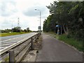
Princess Road
The end of Princess Road leading into Princess Parkway. On the right a footpath leads to the Trans Pennine trail.
Image: © Gerald England
Taken: 21 Jul 2012
0.09 miles
5
River Mersey
Here the Trans Pennine Trail follows the northern bank of the River Mersey. On the left are playing fields. A cycle-track follows the southern bank. Behind the trees is Northenden golf course.
Image: © Gerald England
Taken: 21 Jul 2012
0.10 miles
6
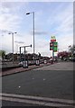
Co-op and McDonald's signs, Princess Road
Image: © David Smith
Taken: 24 Oct 2019
0.11 miles
7
River Mersey
Here the Trans Pennine Trail follows the northern bank of the River Mersey. On the left are playing fields. A cycletrack follows the southern bank. Behind the trees is Northenden golf course.
Image: © Gerald England
Taken: 21 Jul 2012
0.12 miles
8
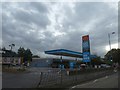
A view up Princess Road
A view up Princess Road in the Barlow Moor area of Manchester. Complete with signage for Texaco petrol and McDonald's.
Image: © Steven Haslington
Taken: 18 Apr 2017
0.12 miles
9
River Mersey
Here the Trans Pennine Trail follows the northern bank of the River Mersey. On the right are playing fields. A cycletrack follows the southern bank. Behind the trees is Northenden golf course.
Image: © Gerald England
Taken: 21 Jul 2012
0.14 miles
10
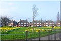
Spring Daffodils - Mersey Bank Avenue
Image: © Anthony Parkes
Taken: 14 Mar 2012
0.14 miles