IMAGES TAKEN NEAR TO
Millgate Lane, MANCHESTER, M20 2SW
Introduction
This page details the photographs taken nearby to Millgate Lane, M20 2SW by members of the Geograph project.
The Geograph project started in 2005 with the aim of publishing, organising and preserving representative images for every square kilometre of Great Britain, Ireland and the Isle of Man.

There are currently over 7.5m images from over14,400 individuals and you can help contribute to the project by visiting https://www.geograph.org.uk
Image Map
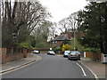
Images are licensed for reuse under creativecommons.org/licenses/by-sa/2.0
Notes
- Clicking on the map will re-center to the selected point.
- The higher the marker number, the further away the image location is from the centre of the postcode.
Image Listing (90 Images Found)
Images are licensed for reuse under creativecommons.org/licenses/by-sa/2.0
Image
Details
Distance
2
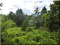
Didsbury, Stenner Woods
An area of mixed woodland, managed by the Mersey Valley Partnership: http://www.woodlandtrust.org.uk/visiting-woods/wood/23885/stenner/
Image: © Mike Faherty
Taken: 3 Aug 2015
0.03 miles
5
Didsbury, Fletcher Moss Gardens
Gifted by local philanthropist Fletcher Moss to Manchester City Council in 1915:http://www.fletchermossgardens.org.uk/index.php?id=history-of-fletcher-moss-park-and-gardens
Image: © Mike Faherty
Taken: 3 Aug 2015
0.09 miles
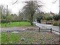
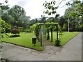
6
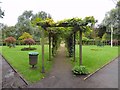
Tree lawn at Fletcher Moss Park
The tree lawn in front of the Alpine House at Fletcher Moss Park was once a walled kitchen garden.
Image: © Gerald England
Taken: 15 Jul 2017
0.10 miles
7
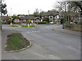
East Didsbury - Parrs Wood Road southern end
This lengthy through route fizzles out amongst suburban housing at the junction ahead. Plans to extend through to Sharston across the River Mersey were shelved many years ago.
Image: © Peter Whatley
Taken: 31 Mar 2009
0.11 miles
8
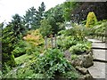
Fletcher Moss Gardens, rockery
Built by local philanthropist Fletcher Moss, and gifted to Manchester City Council in 1915: http://www.fletchermossgardens.org.uk/index.php?id=history-of-fletcher-moss-park-and-gardens
Image: © Mike Faherty
Taken: 3 Aug 2015
0.12 miles
9
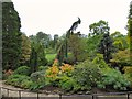
Fletcher Moss Park
The park was gifted to the City of Manchester in 1915 by Fletcher Moss. It covers three separate but linked areas; Fletcher Moss Park and the Botanical Gardens; Parsonage Gardens; the Nature Reserve of Stenner Woods, Millgate Fields and the River Mersey. It is now looked after and cared for by the Friends of Fletcher Moss Park and Gardens. http://www.fletchermossgardens.org.uk/
Image: © Gerald England
Taken: 15 Jul 2017
0.13 miles
10
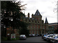
The Towers, Didsbury
The former home of the Victorian engineer Daniel Adamson, now part of a business park. On 27th June 1882 a meeting was held here to start the campaign that led to the construction of the Manchester Ship Canal. (See also Image ). For an account of the life of Adamson's sister, Elizabeth, and an account of Adamson's reception by the people of Didsbury following the passing of the Ship Canal Act see http://www.g4fas.net/fmmm.htm (courtesy of Geoff Royle, http://www.geograph.org.uk/profile/27109 )
Image: © Keith Williamson
Taken: 14 Dec 2005
0.13 miles