IMAGES TAKEN NEAR TO
Mersey Road, MANCHESTER, M20 2PX
Introduction
This page details the photographs taken nearby to Mersey Road, M20 2PX by members of the Geograph project.
The Geograph project started in 2005 with the aim of publishing, organising and preserving representative images for every square kilometre of Great Britain, Ireland and the Isle of Man.

There are currently over 7.5m images from over14,400 individuals and you can help contribute to the project by visiting https://www.geograph.org.uk
Image Map
Images are licensed for reuse under creativecommons.org/licenses/by-sa/2.0
Notes
- Clicking on the map will re-center to the selected point.
- The higher the marker number, the further away the image location is from the centre of the postcode.
Image Listing (32 Images Found)
Images are licensed for reuse under creativecommons.org/licenses/by-sa/2.0
Image
Details
Distance
1
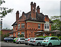
Woodstock Arms, Barlow Moor Road, Manchester
Boisterous pub, built as a private house for E. Rogerson by Asahel Bell & George Freeth Roper in 1877. "An excellent house of Norman Shaw derivation". Grade II listed.
Image: © Stephen Richards
Taken: 26 May 2016
0.05 miles
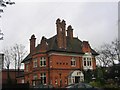
2
The Woodstock Arms
#139 Barlow Moor Road
Originally a large detached late 19th century house. It was listed as Grade II in 1992 http://www.britishlistedbuildings.co.uk/101197801-the-british-council-didsbury-west-ward when it was being used as offices by the British Council. It was converted into a pub-restaurant and in the late 1990s it regularly featured as the local boozer in ITV's "Cold Feet".
Image
Image: © Gerald England
Taken: 17 Feb 2017
0.06 miles
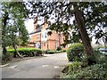
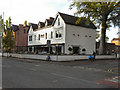
3
The Woodstock, Barlow Moor Road junction with Mersey Road, West Didsbury
Nice beer garden in the summer, recent refurbishment kept the pub closed for weeks, you could hardly tell the difference when it re-opened.
Image: © Paul Ashwin
Taken: 16 Apr 2005
0.07 miles
4
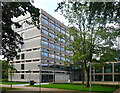
Manchester College, Barlow Moor Road, Manchester
A taste of the 1960s in leafy Didsbury. The end wall even has exposed concrete. Built 1969 by the City Architect's Department. Recently landscaped by the looks of it.
Once Fielden Park College, this is now the Fielden Campus. It appears to be a generalist college, though with an emphasis on vocational courses.
Image: © Stephen Richards
Taken: 25 Jul 2011
0.07 miles
5
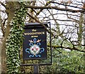
Sign of the Woodstock Arms
Sign for the Woodstock Arms Image
Image: © Gerald England
Taken: 17 Feb 2017
0.07 miles
6
Albert's Restaurant and Bar, West Didsbury
Albert's Restaurant and Bar on Barlow Moor Road.
Image: © David Dixon
Taken: 27 Sep 2011
0.09 miles
7
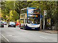
Barlow Moor Road, West Didsbury
A bus, following route 23A towards Stockport, waits at a stop on Barlow Moor Road in West Didsbury.
Image: © David Dixon
Taken: 27 Sep 2011
0.11 miles
8
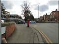
Corner of Burton Road and Barlow Moor Road
On the corner is an Edward VII postbox (M20 616D) Image
Image: © Gerald England
Taken: 17 Feb 2017
0.11 miles
9
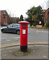
Edward VII postbox (M20 616D)
Postbox on the corner of Burton Road and Barlow Moor Road Image
Image: © Gerald England
Taken: 17 Feb 2017
0.11 miles
10
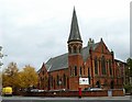
Didsbury Mosque
Previously a Methodist chapel.
Image: © philandju
Taken: 3 Oct 2018
0.12 miles