IMAGES TAKEN NEAR TO
Burton Road, MANCHESTER, M20 2BB
Introduction
This page details the photographs taken nearby to Burton Road, M20 2BB by members of the Geograph project.
The Geograph project started in 2005 with the aim of publishing, organising and preserving representative images for every square kilometre of Great Britain, Ireland and the Isle of Man.

There are currently over 7.5m images from over14,400 individuals and you can help contribute to the project by visiting https://www.geograph.org.uk
Image Map
Images are licensed for reuse under creativecommons.org/licenses/by-sa/2.0
Notes
- Clicking on the map will re-center to the selected point.
- The higher the marker number, the further away the image location is from the centre of the postcode.
Image Listing (76 Images Found)
Images are licensed for reuse under creativecommons.org/licenses/by-sa/2.0
Image
Details
Distance
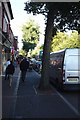
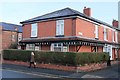
1
Burton Road
At the junction with Nell Street with cafe premises on the corner
Image: © Kevin Waterhouse
Taken: 2 Jun 2023
0.02 miles
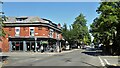
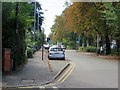
2
West Didsbury - Northen Grove: the odd bit
Around a 90 degree bend from the rest of Northen Grove.
Image: © Peter Whatley
Taken: 31 Mar 2009
0.02 miles
4
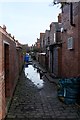
Cobbled back alley
Manchester, as was. And is.
Image: © Bob Harvey
Taken: 30 Jan 2018
0.03 miles
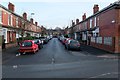
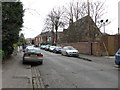
7
Parked cars
The designers of these avenues could never have guessed that each house would have a car to park
Image: © Bob Harvey
Taken: 30 Jan 2018
0.05 miles
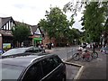
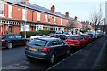
9
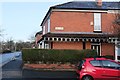
Corner plot
The corner of Arley Avenue, showing the elaborate canopies.
Image: © Bob Harvey
Taken: 30 Jan 2018
0.05 miles