IMAGES TAKEN NEAR TO
The Beeches, MANCHESTER, M20 2AH
Introduction
This page details the photographs taken nearby to The Beeches, M20 2AH by members of the Geograph project.
The Geograph project started in 2005 with the aim of publishing, organising and preserving representative images for every square kilometre of Great Britain, Ireland and the Isle of Man.

There are currently over 7.5m images from over14,400 individuals and you can help contribute to the project by visiting https://www.geograph.org.uk
Image Map
Images are licensed for reuse under creativecommons.org/licenses/by-sa/2.0
Notes
- Clicking on the map will re-center to the selected point.
- The higher the marker number, the further away the image location is from the centre of the postcode.
Image Listing (35 Images Found)
Images are licensed for reuse under creativecommons.org/licenses/by-sa/2.0
Image
Details
Distance
2
Corner of Burton Road and Barlow Moor Road
On the corner is an Edward VII postbox (M20 616D) Image
Image: © Gerald England
Taken: 17 Feb 2017
0.12 miles
3
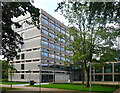
Manchester College, Barlow Moor Road, Manchester
A taste of the 1960s in leafy Didsbury. The end wall even has exposed concrete. Built 1969 by the City Architect's Department. Recently landscaped by the looks of it.
Once Fielden Park College, this is now the Fielden Campus. It appears to be a generalist college, though with an emphasis on vocational courses.
Image: © Stephen Richards
Taken: 25 Jul 2011
0.12 miles
4
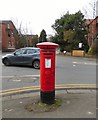
Edward VII postbox (M20 616D)
Postbox on the corner of Burton Road and Barlow Moor Road Image
Image: © Gerald England
Taken: 17 Feb 2017
0.12 miles
5
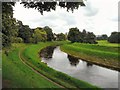
River Mersey
After Northenden the west-flowing River Mersey makes a wide meander northwards towards West Didsbury before turning south and then west again towards Sale. This is the northernmost point of that meander. The Trans Pennine Trail follows the northern bank. A cycletrack follows the southern bank.
Image: © Gerald England
Taken: 21 Jul 2012
0.13 miles
6
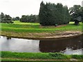
River Mersey
After Northenden the west-flowing River Mersey makes a wide meander Northwards towards West Didsbury before turning south and then west again towards Sale. This is the northernmost point of that meander. The Trans Pennine Trail follows the northern bank. A cycletrack follows the southern bank.
Image: © Gerald England
Taken: 21 Jul 2012
0.13 miles
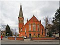
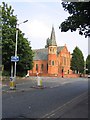
7
Didsbury Mosque
Previously a Methodist chapel.
Image: © philandju
Taken: 3 Oct 2018
0.14 miles
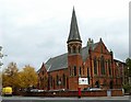
8
Didsbury Mosque
The former Albert Park Methodist Church, on the corner of Barlow Moor Road and Burton Road, is a Gothic-style church built in orange-red Manchester brick with yellow stone dressings. It has a bell tower with a modest spire and slate roof.
It opened for worship in 1883, but in 1962 the chapel closed and was later converted into The Manchester Islamic Centre.
In 1967 it was bought by some donors from the Syrian Arab community. The property consists of two large buildings, the first one is used as a mosque and library, while the second is used as prayer hall for women, a lecture and events room, classrooms, a kitchen, ablution area for men and one for women. http://didsburymosque.com/
Image: © Gerald England
Taken: 17 Feb 2017
0.14 miles
9
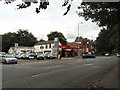
Barlow Moor Filling Station
On the corner of Elizabeth Slinger Road and Barlow Moor Road, the A5145 from Stretford and Chorlton to Didsbury and Stockport.
Image: © Gerald England
Taken: 21 Jul 2012
0.14 miles
10
Church
This building is on the corner of Burton road and Barlow Moor Road in the West Didsbury area of Manchester. The picture was taken from SJ837918 looking North east.
Image: © Dave Smethurst
Taken: 5 Sep 2005
0.15 miles