IMAGES TAKEN NEAR TO
Buxton Avenue, MANCHESTER, M20 1JT
Introduction
This page details the photographs taken nearby to Buxton Avenue, M20 1JT by members of the Geograph project.
The Geograph project started in 2005 with the aim of publishing, organising and preserving representative images for every square kilometre of Great Britain, Ireland and the Isle of Man.

There are currently over 7.5m images from over14,400 individuals and you can help contribute to the project by visiting https://www.geograph.org.uk
Image Map
Images are licensed for reuse under creativecommons.org/licenses/by-sa/2.0
Notes
- Clicking on the map will re-center to the selected point.
- The higher the marker number, the further away the image location is from the centre of the postcode.
Image Listing (58 Images Found)
Images are licensed for reuse under creativecommons.org/licenses/by-sa/2.0
Image
Details
Distance
1
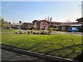
Dermot Murphy Close
Outside the Minehead Centre.
Image: © Gerald England
Taken: 22 Apr 2010
0.13 miles
2
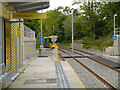
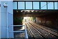
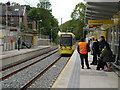
Burton Road Metrolink Stop
Metrolink Bombardier M5000 number 3042 leaves the new Burton Road tram stop on the first day of operation for the latest extension to the South Manchester Metrolink line.
The Metrolink line to East Didsbury, which runs along the disused railway track, opened to passenger service on Thursday 23 May, several months ahead of schedule. The 4.4km (2.7 miles) extension to the existing South Manchester line has five new stops, with services calling at Withington, Burton Road, West Didsbury, Didsbury Village and East Didsbury.
Image: © David Dixon
Taken: 23 May 2013
0.18 miles
3
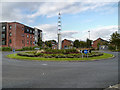
Didsbury Point, The Boulevard
Didsbury Point is a new development on the site of the former Withington Hospital in South Manchester. This sculpture is in the middle of a traffic island on "the Boulevard".
Image: © David Dixon
Taken: 17 Sep 2012
0.18 miles
5
Into the sunlight
A tram to Didsbury vanishing into the sunlight from Withington Tram Stop
Image: © Bob Harvey
Taken: 25 Oct 2017
0.19 miles
6

St Bernadette's Tower
Image: © Gerald England
Taken: 13 May 2017
0.19 miles
7
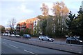
Apartments on Princess Road
Late sun catching the architecture
Image: © Bob Harvey
Taken: 25 Oct 2017
0.19 miles
8
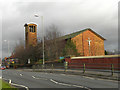
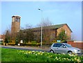
Saint Bernadette's Church
Saint Bernadette's Roman Catholic Church, on Princess Road, was opened in 1958.
Image: © David Dixon
Taken: 7 Jan 2012
0.19 miles
9
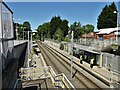
Burton Road Metrolink Station
Viewed from the access from Burton Road
Image: © Kevin Waterhouse
Taken: 2 Jun 2023
0.19 miles
10
Metrolink Tram at Burton Road
Metrolink Bombardier M5000 number 3033 approaches the new Burton Road stop, heading towards East Didsbury on the first day of operation for the latest extension to the South Manchester Metrolink line.
The Metrolink line to East Didsbury, which runs along the disused railway track, opened to passenger service on Thursday 23 May, several months ahead of schedule. The 4.4km (2.7 miles) extension to the existing South Manchester line has five new stops, with services calling at Withington, Burton Road, West Didsbury, Didsbury Village and East Didsbury.
Image: © David Dixon
Taken: 23 May 2013
0.19 miles