IMAGES TAKEN NEAR TO
Lynmouth Avenue, MANCHESTER, M20 1FA
Introduction
This page details the photographs taken nearby to Lynmouth Avenue, M20 1FA by members of the Geograph project.
The Geograph project started in 2005 with the aim of publishing, organising and preserving representative images for every square kilometre of Great Britain, Ireland and the Isle of Man.

There are currently over 7.5m images from over14,400 individuals and you can help contribute to the project by visiting https://www.geograph.org.uk
Image Map
Images are licensed for reuse under creativecommons.org/licenses/by-sa/2.0
Notes
- Clicking on the map will re-center to the selected point.
- The higher the marker number, the further away the image location is from the centre of the postcode.
Image Listing (13 Images Found)
Images are licensed for reuse under creativecommons.org/licenses/by-sa/2.0
Image
Details
Distance
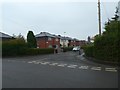
1
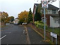
End of footpath from Longport Avenue to Whitchurch Road, Withington
Between the hedges is one of several narrow footpaths between roads in this housing estate
Image: © David Smith
Taken: 24 Oct 2019
0.13 miles
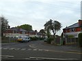
2
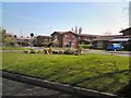
Tiles and open space at south end of Doncaster Avenue, Withington
Image: © David Smith
Taken: 24 Oct 2019
0.15 miles
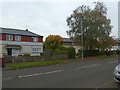
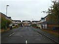
4
Hasper Avenue, Withington from Whitchurch Road
Image: © David Smith
Taken: 24 Oct 2019
0.16 miles
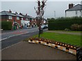
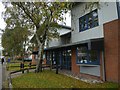
5
Dermot Murphy Close
Outside the Minehead Centre.
Image: © Gerald England
Taken: 22 Apr 2010
0.17 miles
8
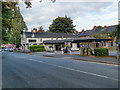
The Old House at Home, Burton Road, Withington
Image: © David Dixon
Taken: 17 Sep 2012
0.22 miles
9
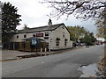
The Old House at Home pub, Burton Road, Withington, Manchester
Nice friendly local pub.
Image: © Jeremy Bolwell
Taken: 30 Oct 2013
0.22 miles