IMAGES TAKEN NEAR TO
Mouldsworth Avenue, MANCHESTER, M20 1AW
Introduction
This page details the photographs taken nearby to Mouldsworth Avenue, M20 1AW by members of the Geograph project.
The Geograph project started in 2005 with the aim of publishing, organising and preserving representative images for every square kilometre of Great Britain, Ireland and the Isle of Man.

There are currently over 7.5m images from over14,400 individuals and you can help contribute to the project by visiting https://www.geograph.org.uk
Image Map
Images are licensed for reuse under creativecommons.org/licenses/by-sa/2.0
Notes
- Clicking on the map will re-center to the selected point.
- The higher the marker number, the further away the image location is from the centre of the postcode.
Image Listing (21 Images Found)
Images are licensed for reuse under creativecommons.org/licenses/by-sa/2.0
Image
Details
Distance
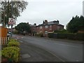
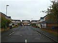
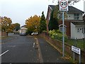
4
Doncaster Avenue houses, Withington
Some of the road names in this area are on house fronts, not at street level
Image: © David Smith
Taken: 24 Oct 2019
0.13 miles
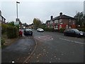
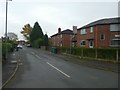
8
Somerford Avenue
A narrow road leading into a cul-de-sac
Image: © David Smith
Taken: 24 Oct 2019
0.18 miles
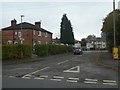
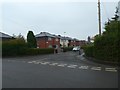
9
Hasper Avenue, Withington from Whitchurch Road
Image: © David Smith
Taken: 24 Oct 2019
0.18 miles