IMAGES TAKEN NEAR TO
Langland Close, MANCHESTER, M19 3YN
Introduction
This page details the photographs taken nearby to Langland Close, M19 3YN by members of the Geograph project.
The Geograph project started in 2005 with the aim of publishing, organising and preserving representative images for every square kilometre of Great Britain, Ireland and the Isle of Man.

There are currently over 7.5m images from over14,400 individuals and you can help contribute to the project by visiting https://www.geograph.org.uk
Image Map
Images are licensed for reuse under creativecommons.org/licenses/by-sa/2.0
Notes
- Clicking on the map will re-center to the selected point.
- The higher the marker number, the further away the image location is from the centre of the postcode.
Image Listing (10 Images Found)
Images are licensed for reuse under creativecommons.org/licenses/by-sa/2.0
Image
Details
Distance
1
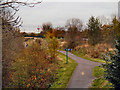
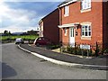
Fallowfield Loop Line
The disused railway line, now part of the National Cycle Network Route 6, looking north from Longford Road West.
Image: © David Dixon
Taken: 7 Nov 2012
0.11 miles
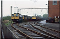
2
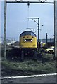
On the shed
Class 40 40179 is waiting attention outside Reddish shed. At this time Reddish had heavy lifting gear as well as tyre reprofiling equipment. It was quite a busy engineering depot repairing and servicing locomotives for the North West area of British Rail as well as the base for the Woodhead line class 76 electric locomotives. With the closure of the Woodhead line in early 1981 the depot lost most of its work and was shut. The buildings have all been razed to the ground. Even the freight line that went by the depot has closed and been lifted.
Image: © roger geach
Taken: Unknown
0.15 miles
3
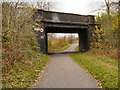
Fallowfield Loop Line, Bridge at Longford Road East
Bridge 13 on the former Fallowfield Loop Line (disused railway) now part of the National Cycle Network Route 6.
Image: © David Dixon
Taken: 7 Nov 2012
0.16 miles
4
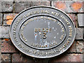
Bridge 13 plaque
The plaque attached to the bridge at Longford Road West (Image]) indicates the original railway route
MANCHESTER, SHEFFIELD & LINCOLNSHIRE RAILWAY 1892
and SUSTRANS 2002 (indicating its part in the National Cycle Network)
It is very similar to Image] but the name MANCHESTER has been replaced by STOCKPORT indicating that this part of the route is within the Stockport Metropolitan Borough.
Image: © David Dixon
Taken: 7 Nov 2012
0.16 miles
5
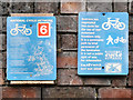
National Cycle Network Signs
Sign attached to the bridge at Longford Road West (Image]). The one on the left hand side reads:
This is part of the National Cycle
Network. This 10,000 mile project
is being developed by a partnership
of local authorities and others,
and is co-ordinated by the
charity Sustrans.
As far as possible, the National Cycle Network
follows quiet roads or purpose
built traffic-free paths to avoid
main roads. It aims to
connect the centre of
each town along the way.
Traffic free sections are
used by walkers, cyclists
and sometimes horses.
Please respect other users.
For more information on routes
in your area contact Sustrans
0117 929 0888 or visit
www.nationalcyclenetwork.org.uk
The one on the right reads:
Sustrans has
negotiated
this route for
the use of non-
motorised
travellers only.
It is a permissive
path by kind
permission of
the landowner.
It is not a public
right of way.
For information
Sustrans
0117 929 0888
Image: © David Dixon
Taken: 7 Nov 2012
0.16 miles
6
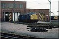
Reddish Loco Depot
40055 sits outside Reddish Depot. This shed was constructed in 1954 to be the primary maintenance depot for the 1500v electric locomotives operating over the Woodhead Route between Manchester and Sheffield via Penistone. It also maintained the Manchester - Glossop/Hadfield electric units, one of which can be seen on the right of the photo. The Woodhead Route closed in 1981 and the depot closed in 1983. Although the buildings were subsequently demolished, their footprint is still visible on Google maps at this time.
Image: © Martin Addison
Taken: Unknown
0.20 miles
7
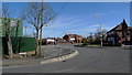
The serpentine road at the Tallyrand junction
Legend has it that Tallyrand is named after a French nobleman http://wapedia.mobi/en/Talleyrand who found refuge nearby at the time of the French Revolution. The road from left to right connects Levenshulme http://wapedia.mobi/en/Levenshulme and Reddish, and the peculiar S-bend follows ancient field boundaries.
Image: © Geoff Royle
Taken: 4 Mar 2010
0.20 miles
8
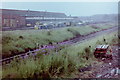
Reddish Locomotive Depot, 1981
By 2015, this had mostly become a housing estate.
Image: © Nigel Thompson
Taken: 22 Jul 1981
0.21 miles
10
Reddish Loco Depot
Rows of class 76 1500v DC electric locomotives stand beside the depot buildings. Built for the Woodhead route in the early 1950's, the decision in the late 1950's to go for 25Kv AC traction on future electrifications made them obsolescent overnight. The Woodhead route closed in 1981 and the class were withdrawn en-masse in July of that year.
Image: © Martin Addison
Taken: Unknown
0.21 miles