IMAGES TAKEN NEAR TO
Atlas Place, MANCHESTER, M19 3XR
Introduction
This page details the photographs taken nearby to Atlas Place, M19 3XR by members of the Geograph project.
The Geograph project started in 2005 with the aim of publishing, organising and preserving representative images for every square kilometre of Great Britain, Ireland and the Isle of Man.

There are currently over 7.5m images from over14,400 individuals and you can help contribute to the project by visiting https://www.geograph.org.uk
Image Map (Loading...)


Getting Data...Please wait
Leaflet Map data © OpenStreetMap
Images are licensed for reuse under creativecommons.org/licenses/by-sa/2.0
Notes
- Clicking on the map will re-center to the selected point.
- The higher the marker number, the further away the image location is from the centre of the postcode.
Image Listing (134 Images Found)
Images are licensed for reuse under creativecommons.org/licenses/by-sa/2.0
Image
Details
Distance
1
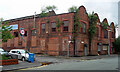
Former works, Chapel Street, Manchester
Street front with four shaped gables still bearing the name, "The Atlas Engineering Works".
Demolished a few years later for 64 homes in Manchester’s first ‘rent to buy’ housing scheme whereby homes can be rented at a discounted rate while residents save for the deposit to buy the property.
Image: © Stephen Richards
Taken: 14 Jun 2016
0.00 miles
2
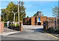
St Mary of the Angels and St Clare
According to the Genuki website http://www.genuki.org.uk/big/eng/LAN/Levenshulme/StMaryoftheAngelsandStClare.shtml the church was founded in 1853 and was originally attached to the Convent of the Poor Clares, Clare Road, Levenshulme. A new church opened in 1883. In 1957 it then moved to a former cinema on Stockport Road and in 1975 moved into this new building on Elbow Street.
Image: © Gerald England
Taken: 1 Oct 2011
0.08 miles
3
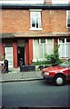
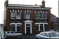
Terraced House - Ratcliffe Street Levenshulme
Image: © Anthony Parkes
Taken: 10 Jun 1994
0.08 miles
5
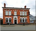
The Horseshoe
Public house on Chapel Street, Levenshulme. Before 2008 it was a Wilson's house Image Some old photos can be seen on "Levenshulme Around Town": http://www.levyboy.com/around_town.htm
Image
Image: © Gerald England
Taken: 29 Apr 2017
0.09 miles
6
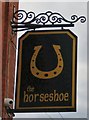
The sign of the Horseshoe
Sign for the Horseshoe Image
Image: © Gerald England
Taken: 29 Apr 2017
0.09 miles
7
The Horseshoe Inn - Chapel Street, Levenshulme
Image: © Frank Airey
Taken: 1 Jul 1979
0.09 miles
8
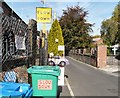
Slow Down Please
A series of signs on Elbow Road, Levenshulme.
Image: © Gerald England
Taken: 1 Oct 2011
0.09 miles
9
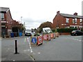
Traffic calming in Levenshulme
These "modal filters" were installed in Delamere Road in January 2021. The initial planters were vandalised as reported in the Manchester Evening News https://www.manchestereveningnews.co.uk/news/greater-manchester-news/levenshulme-plant-filters-installed-trial-19566982
The filters came about due to an initiative from Streets for People - Levenshulme and Burnage https://streetsforpeople.co.uk/
Image: © Gerald England
Taken: 9 Oct 2021
0.09 miles
10
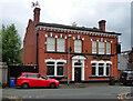
The Horseshoe, Chapel Street, Manchester
A pub just off Stockport Road in Levenshulme.
Image: © Stephen Richards
Taken: 14 Jun 2016
0.09 miles