IMAGES TAKEN NEAR TO
Alma Road, MANCHESTER, M19 3NW
Introduction
This page details the photographs taken nearby to Alma Road, M19 3NW by members of the Geograph project.
The Geograph project started in 2005 with the aim of publishing, organising and preserving representative images for every square kilometre of Great Britain, Ireland and the Isle of Man.

There are currently over 7.5m images from over14,400 individuals and you can help contribute to the project by visiting https://www.geograph.org.uk
Image Map
Images are licensed for reuse under creativecommons.org/licenses/by-sa/2.0
Notes
- Clicking on the map will re-center to the selected point.
- The higher the marker number, the further away the image location is from the centre of the postcode.
Image Listing (127 Images Found)
Images are licensed for reuse under creativecommons.org/licenses/by-sa/2.0
Image
Details
Distance
1
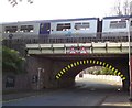
Alma Road Bridge
The bridge carries the main Manchester to Stockport railway line over Alma Road. The arch bridge has a height restriction of 11' 3" (3.4m).
Image: © Gerald England
Taken: 31 Oct 2019
0.02 miles
2
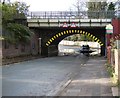
Alma Road Bridge
The bridge carries the main Manchester to Stockport railway line over Alma Road. The arch bridge has a height restriction of 11' 3" (3.4m). At times of heavy rain the road underneath gets flooded.
Image: © Gerald England
Taken: 27 Oct 2019
0.03 miles
3
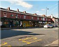
Levenshulme shops
Shops on Stockport Road, Levenshulme.
Image: © Gerald England
Taken: 1 Oct 2011
0.04 miles
4
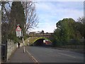
Alma Road Bridge
The bridge carries the main Manchester to Stockport railway line over Alma Road. The arch bridge has a height of 11' 3".
Image: © Gerald England
Taken: 31 Oct 2019
0.04 miles
5
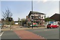
Stockport Road, Levenshulme
The premises on the corner of Elbow Street, formerly Morley's News, have now been demolished. Tony's barber shop next door is protected by scaffolding.
Image: © Gerald England
Taken: 21 Apr 2018
0.04 miles
6
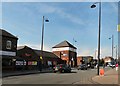
Tesco Metro, Levenshulme
The Tesco Metro store on Stockport Road.
Image: © Gerald England
Taken: 1 Oct 2011
0.04 miles
7
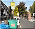
Slow Down Please
A series of signs on Elbow Road, Levenshulme.
Image: © Gerald England
Taken: 1 Oct 2011
0.06 miles
8
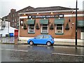
Fiddlers Green
An Irish pub on Stockport Road, Levenshulme.
Image: © Gerald England
Taken: 2 Jan 2018
0.07 miles
9
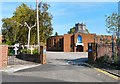
St Mary of the Angels and St Clare
According to the Genuki website http://www.genuki.org.uk/big/eng/LAN/Levenshulme/StMaryoftheAngelsandStClare.shtml the church was founded in 1853 and was originally attached to the Convent of the Poor Clares, Clare Road, Levenshulme. A new church opened in 1883. In 1957 it then moved to a former cinema on Stockport Road and in 1975 moved into this new building on Elbow Street.
Image: © Gerald England
Taken: 1 Oct 2011
0.08 miles
10
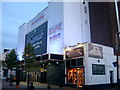
Nawaab restaurant Levenshulme
This is the refurbished Nawaab restaurant situated on the A6 Stockport Road Levenshulme Manchester, this building was previously a bingo club, and before that a cinema.
Image: © GARY TAYLOR
Taken: 12 May 2005
0.08 miles