IMAGES TAKEN NEAR TO
Ravenoak Avenue, MANCHESTER, M19 3LW
Introduction
This page details the photographs taken nearby to Ravenoak Avenue, M19 3LW by members of the Geograph project.
The Geograph project started in 2005 with the aim of publishing, organising and preserving representative images for every square kilometre of Great Britain, Ireland and the Isle of Man.

There are currently over 7.5m images from over14,400 individuals and you can help contribute to the project by visiting https://www.geograph.org.uk
Image Map
Images are licensed for reuse under creativecommons.org/licenses/by-sa/2.0
Notes
- Clicking on the map will re-center to the selected point.
- The higher the marker number, the further away the image location is from the centre of the postcode.
Image Listing (28 Images Found)
Images are licensed for reuse under creativecommons.org/licenses/by-sa/2.0
Image
Details
Distance
1
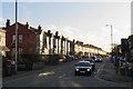
Broom Lane
The houses are lit by late winter sun.
Image: © Bill Boaden
Taken: 10 Jan 2020
0.18 miles
2
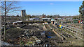
Public allotments, Levenshulme
This view looking from ' Tallyrand ' shows part of a huge acreage of public allotments. The block of flats centre left is Cundiff Court, a social housing development. The famous architect Norman Foster designer of many impressive buildings worldwide e.g. London's Gherkin, grew up in streets nearby, in fact his birthplace in Reddish is not far behind the camera position.
Image: © Geoff Royle
Taken: 4 Mar 2010
0.18 miles
3
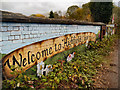
Welcome to Highfield Country Park
Sign painted on the wall of the former railway bridge at the Highfield Road entrance to the country park.
Highfield Country Park is situated to the east of Levenshulme. It is a 70 acre area of open land that stretches to the east of Broom Avenue across to the back of Houldsworth Golf Course and over to the junction of Longford Road and Nelstrop Road.
The land was used to extract clay for the manufacture of bricks for the building industry; the clay pit and brick works existed until the 1950s when it was being operated by the Jackson Brick Company. Other businesses that have occupied the site included the UCP tripe factory, Levenshulme Dye and Bleach works, and, originally, High Field Farm.
In the 1970s, by which time it was little more than a landfill site, the area was designated as a country park by Manchester City Council. During the period 2004-5 the park was transformed from a dreary, vandalised wasteland into a country park with a picnic area and mapped out country walks. (http://www2.btcv.org.uk/manchester.pdf "Case Study: Highfield Country Park, Manchester" (PDF). BTCV Grass Roots)
In November 2007, Highfield Country Park was declared a protected habitat for many animal and plant species.
http://en.wikipedia.org/wiki/Highfield_Country_Park Wikipedia
Image: © David Dixon
Taken: 7 Nov 2012
0.19 miles
4
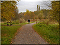
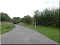
Highfield Country Park
Footpath at the end of Highfield Road.
Highfield Country Park is situated to the east of Levenshulme. It is a 70 acre area of open land that stretches to the east of Broom Avenue across to the back of Houldsworth Golf Course and over to the junction of Longford Road and Nelstrop Road.
The land was used to extract clay for the manufacture of bricks for the building industry; the clay pit and brick works existed until the 1950s when it was being operated by the Jackson Brick Company. Other businesses that have occupied the site included the UCP tripe factory, Levenshulme Dye and Bleach works, and, originally, High Field Farm.
In the 1970s, by which time it was little more than a landfill site, the area was designated as a country park by Manchester City Council. During the period 2004-5 the park was transformed from a dreary, vandalised wasteland into a country park with a picnic area and mapped out country walks. (http://www2.btcv.org.uk/manchester.pdf "Case Study: Highfield Country Park, Manchester" (PDF). BTCV Grass Roots)
In November 2007, Highfield Country Park was declared a protected habitat for many animal and plant species.
http://en.wikipedia.org/wiki/Highfield_Country_Park Wikipedia
Image: © David Dixon
Taken: 7 Nov 2012
0.20 miles
5
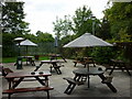
The Blue Bell, Levenshulme, Manchester
The beer garden at this Sam Smith's public house.
Image: © Ian S
Taken: 29 Jul 2011
0.20 miles
6
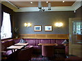
The Blue Bell, Levenshulme, Manchester
One of the rooms in this Sam Smith's public house.
Image: © Ian S
Taken: 29 Jul 2011
0.21 miles
7
Fairfield Loop
Approaching Broom Lane bridge. On the left is a National Cycle Network Milepost Image
Image: © Gerald England
Taken: 9 Oct 2021
0.21 miles
8
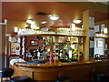
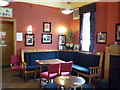
The Blue Bell, Levenshulme, Manchester
The main bar in this Sam Smith's public house.
Image: © Ian S
Taken: 29 Jul 2011
0.21 miles
9
The Blue Bell, Levenshulme, Manchester
One of three rooms in this Sam Smith's public house.
Image: © Ian S
Taken: 29 Jul 2011
0.21 miles
10
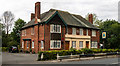
Blue Bell Inn
The Blue Bell Inn on Barlow Road.
Image: © Peter McDermott
Taken: 2 Jul 2019
0.21 miles