IMAGES TAKEN NEAR TO
Elsa Road, MANCHESTER, M19 3JG
Introduction
This page details the photographs taken nearby to Elsa Road, M19 3JG by members of the Geograph project.
The Geograph project started in 2005 with the aim of publishing, organising and preserving representative images for every square kilometre of Great Britain, Ireland and the Isle of Man.

There are currently over 7.5m images from over14,400 individuals and you can help contribute to the project by visiting https://www.geograph.org.uk
Image Map
Images are licensed for reuse under creativecommons.org/licenses/by-sa/2.0
Notes
- Clicking on the map will re-center to the selected point.
- The higher the marker number, the further away the image location is from the centre of the postcode.
Image Listing (28 Images Found)
Images are licensed for reuse under creativecommons.org/licenses/by-sa/2.0
Image
Details
Distance
1
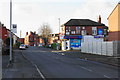
Corner shop on Barlow Road
On the corner of Barlow Road and Peter Moss Way. The Polygon Hotel, now closed, as at the far end of the road.
Image: © Bill Boaden
Taken: 10 Jan 2020
0.03 miles
3
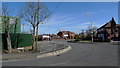
The serpentine road at the Tallyrand junction
Legend has it that Tallyrand is named after a French nobleman http://wapedia.mobi/en/Talleyrand who found refuge nearby at the time of the French Revolution. The road from left to right connects Levenshulme http://wapedia.mobi/en/Levenshulme and Reddish, and the peculiar S-bend follows ancient field boundaries.
Image: © Geoff Royle
Taken: 4 Mar 2010
0.10 miles
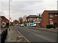
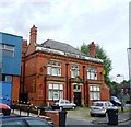
4
Polygon Hotel
The Polygon Hotel at the corner of Printworks Lane and Barlow Road in Levenshulme.
Image: © David Dixon
Taken: 7 Nov 2012
0.10 miles
6
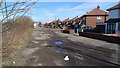
Pot-holes on Nelstrop Road North
This road surfacing has been in an unfinished state for at least sixty years.
Probably a result of poor liaison between a builder and the local Authority,
and in the meantime an embarrassing nightmare for the local householders.
In the distance is the serpentine road junction at Tallyrand http://www.geograph.org.uk/photo/1737043.
Image: © Geoff Royle
Taken: 4 Mar 2010
0.11 miles
7
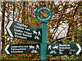
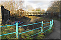
Cyclepath Signpost, Fallowfield Loop Line
Sign on the disused railway (now part of the National Cycle Network Route 6) near the bridge at Nelstrop Road.
Image: © David Dixon
Taken: 7 Nov 2012
0.13 miles
8
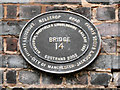
Bridge 14 plaque
Plaque attached to the bridge at Nelstrop Road (Image]). Indicates the original railway route
MANCHESTER, SHEFFIELD & LINCOLNSHIRE RAILWAY 1892
and SUSTRANS 2002 (indicating its part in the National Cycle Network)
also MANCHESTER indicating that this part of the route is within the City of Manchester.
Image: © David Dixon
Taken: 7 Nov 2012
0.13 miles
9
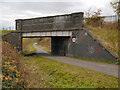
Fallowfield Loop Line, Bridge#14 (Nelstrop Road)
Bridge 14 on the former Fallowfield Loop Line (disused railway) now part of the National Cycle Network.
Image: © David Dixon
Taken: 7 Nov 2012
0.14 miles
10
Path down to the Fallowfield Loop
A junction of cycle routes.
Image: © Bill Boaden
Taken: 10 Jan 2020
0.14 miles