IMAGES TAKEN NEAR TO
Printworks Lane, MANCHESTER, M19 3HS
Introduction
This page details the photographs taken nearby to Printworks Lane, M19 3HS by members of the Geograph project.
The Geograph project started in 2005 with the aim of publishing, organising and preserving representative images for every square kilometre of Great Britain, Ireland and the Isle of Man.

There are currently over 7.5m images from over14,400 individuals and you can help contribute to the project by visiting https://www.geograph.org.uk
Image Map
Images are licensed for reuse under creativecommons.org/licenses/by-sa/2.0
Notes
- Clicking on the map will re-center to the selected point.
- The higher the marker number, the further away the image location is from the centre of the postcode.
Image Listing (22 Images Found)
Images are licensed for reuse under creativecommons.org/licenses/by-sa/2.0
Image
Details
Distance
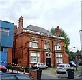
2
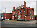
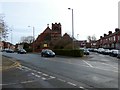
Polygon Hotel
The Polygon Hotel at the corner of Printworks Lane and Barlow Road in Levenshulme.
Image: © David Dixon
Taken: 7 Nov 2012
0.06 miles
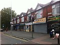
4
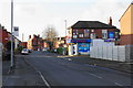
Corner shop on Barlow Road
On the corner of Barlow Road and Peter Moss Way. The Polygon Hotel, now closed, as at the far end of the road.
Image: © Bill Boaden
Taken: 10 Jan 2020
0.10 miles
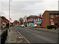
5
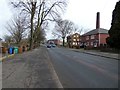
Mount Road
The B6178 from South Levenshulme to Belle Vue. The #201 bus in the background is on a long diversionary route due to closure of the A57 for bridge removal work.
Image: © Gerald England
Taken: 7 Mar 2020
0.11 miles
6
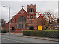
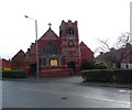
St Mark's Church, Levenshulme
St Mark's Church is on the corner of Barlow Road and Mount Road, Levenshulme.
Image: © David Dixon
Taken: 7 Nov 2012
0.14 miles
8
St Mark's, Levenshulme
St Mark’s Church opened its doors in 1908 to serve the growing community of the Tallyrand or Back Levenshulme area, as the eastern part of Levenshulme was known locally at the time. Prior to this, from 1883, meetings had been held in the Old Mission Room. The number of worshippers grew too large for the space and in 1894 they moved into the New Church School Building, where they remained until the church itself was built. It is now part of the combined Parish of St Peter and St Mark. https://stpeterandstmarklevenshulme.org.uk/about-2/
Image: © Gerald England
Taken: 7 Mar 2020
0.14 miles
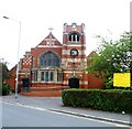
9
St Mark's, Levenshulme
St Mark’s Church opened its doors in 1908 to serve the growing community of the Tallyrand or Back Levenshulme area, as the eastern part of Levenshulme was known locally at the time. Prior to this, from 1883, meetings had been held in the Old Mission Room. The number of worshippers grew too large for the space and in 1894 they moved into the New Church School Building, where they remained until the church itself was built. It is now part of the combined Parish of St Peter and St Mark. https://stpeterandstmarklevenshulme.org.uk/about-2/
Image: © Gerald England
Taken: 7 Mar 2020
0.14 miles