IMAGES TAKEN NEAR TO
Chapel Street, MANCHESTER, M19 3GJ
Introduction
This page details the photographs taken nearby to Chapel Street, M19 3GJ by members of the Geograph project.
The Geograph project started in 2005 with the aim of publishing, organising and preserving representative images for every square kilometre of Great Britain, Ireland and the Isle of Man.

There are currently over 7.5m images from over14,400 individuals and you can help contribute to the project by visiting https://www.geograph.org.uk
Image Map
Images are licensed for reuse under creativecommons.org/licenses/by-sa/2.0
Notes
- Clicking on the map will re-center to the selected point.
- The higher the marker number, the further away the image location is from the centre of the postcode.
Image Listing (133 Images Found)
Images are licensed for reuse under creativecommons.org/licenses/by-sa/2.0
Image
Details
Distance
1
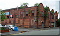
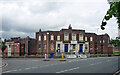
Former works, Chapel Street, Manchester
Street front with four shaped gables still bearing the name, "The Atlas Engineering Works".
Demolished a few years later for 64 homes in Manchester’s first ‘rent to buy’ housing scheme whereby homes can be rented at a discounted rate while residents save for the deposit to buy the property.
Image: © Stephen Richards
Taken: 14 Jun 2016
0.04 miles
2
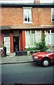
Terraced House - Ratcliffe Street Levenshulme
Image: © Anthony Parkes
Taken: 10 Jun 1994
0.05 miles
4
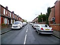
Traffic calming in Levenshulme
These "modal filters" were installed in Delamere Road in January 2021. The initial planters were vandalised as reported in the Manchester Evening News https://www.manchestereveningnews.co.uk/news/greater-manchester-news/levenshulme-plant-filters-installed-trial-19566982
The filters came about due to an initiative from Streets for People - Levenshulme and Burnage https://streetsforpeople.co.uk/
Image: © Gerald England
Taken: 9 Oct 2021
0.08 miles
5
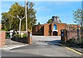
St Mary of the Angels and St Clare
According to the Genuki website http://www.genuki.org.uk/big/eng/LAN/Levenshulme/StMaryoftheAngelsandStClare.shtml the church was founded in 1853 and was originally attached to the Convent of the Poor Clares, Clare Road, Levenshulme. A new church opened in 1883. In 1957 it then moved to a former cinema on Stockport Road and in 1975 moved into this new building on Elbow Street.
Image: © Gerald England
Taken: 1 Oct 2011
0.11 miles
7
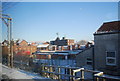
Levenshulme Pools
The historic Levenshulme swimming baths were saved from closure by a public campaign in 2011 (http://www.bbc.co.uk/news/uk-england-manchester-12600450 BBC News).
However, a newly-built Joint Service Centre incorporating a pool, gym and library has now been proposed for the area and so the future of the 1930s building which is not listed, unlike the Carnegie library opposite, seems uncertain (http://menmedia.co.uk/southmanchesterreporter/news/s/1508732_dont-give-up-on-levenshulme-baths-plea- MEN South Manchester Reporter).
Image: © David Dixon
Taken: 7 Nov 2012
0.12 miles
9
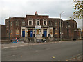
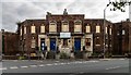
Former baths, Cromwell Grove, Manchester
Levenshulme Baths, by George Noel Hill, City Architect, 1931.
It closed in 2012 due to council spending cuts, and at 2020 little had changed since this picture.
Image: © Stephen Richards
Taken: 14 Jun 2016
0.12 miles
10
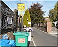
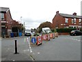
Slow Down Please
A series of signs on Elbow Road, Levenshulme.
Image: © Gerald England
Taken: 1 Oct 2011
0.13 miles